
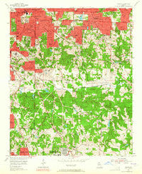
~ Conley GA topo map, 1:24000 scale, 7.5 X 7.5 Minute, Historical, 1954, updated 1965
Conley, Georgia, USGS topographic map dated 1954.
Includes geographic coordinates (latitude and longitude). This topographic map is suitable for hiking, camping, and exploring, or framing it as a wall map.
Printed on-demand using high resolution imagery, on heavy weight and acid free paper, or alternatively on a variety of synthetic materials.
Topos available on paper, Waterproof, Poly, or Tyvek. Usually shipping rolled, unless combined with other folded maps in one order.
- Product Number: USGS-5361214
- Free digital map download (high-resolution, GeoPDF): Conley, Georgia (file size: 16 MB)
- Map Size: please refer to the dimensions of the GeoPDF map above
- Weight (paper map): ca. 55 grams
- Map Type: POD USGS Topographic Map
- Map Series: HTMC
- Map Verison: Historical
- Cell ID: 42320
- Scan ID: 245385
- Imprint Year: 1965
- Woodland Tint: Yes
- Aerial Photo Year: 1952
- Field Check Year: 1954
- Datum: NAD27
- Map Projection: Polyconic
- Map published by United States Geological Survey
- Map Language: English
- Scanner Resolution: 600 dpi
- Map Cell Name: Southeast Atlanta
- Grid size: 7.5 X 7.5 Minute
- Date on map: 1954
- Map Scale: 1:24000
- Geographical region: Georgia, United States
Neighboring Maps:
All neighboring USGS topo maps are available for sale online at a variety of scales.
Spatial coverage:
Topo map Conley, Georgia, covers the geographical area associated the following places:
- Millrun - Ormewood - Blue Creek Forest - Lincolndale - Manor Ridge Park - Conley Downs - Ash Manor - Tara Heights - Harry Pooles Mobile Home Park - Eastland Heights - South Bend - Pinecrest Hills - Blair Village - Blue Creek - Cedar Grove - Oak View Homes - Panthersville - Cedar Valley - Norton (historical) - Sweetbriar - Woodcrest - Briar Glen - Mountain View Plaza - Pleasant Acres - Henrico - Country Pine Estates - Palisades Estates - Cherokee Forest - Gresham Park - Tolliver Heights - Elizabeth Park - Cornell - Ridgewood - Wishing Well Hills - Rovena Acres - Tamarack - Forest Ridge - Rocklane Estates - Rock Spring - Beulah Heights - Glenwood Hills - Miramar - Conley - Thomasville - Riverside Station - Hyde Park Mobile Home Park - Doral Park - Constitution - Cabbage Town - Whitehall Forest Estates - Brownwood - Woodland Park - East Atlanta - Skyline Forest - Weather Wood - River Hills - Cedar Grove Acres - Fairfield Lakes
- Map Area ID: AREA33.7533.625-84.375-84.25
- Northwest corner Lat/Long code: USGSNW33.75-84.375
- Northeast corner Lat/Long code: USGSNE33.75-84.25
- Southwest corner Lat/Long code: USGSSW33.625-84.375
- Southeast corner Lat/Long code: USGSSE33.625-84.25
- Northern map edge Latitude: 33.75
- Southern map edge Latitude: 33.625
- Western map edge Longitude: -84.375
- Eastern map edge Longitude: -84.25


