
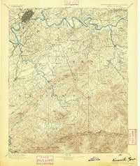
~ Knoxville TN topo map, 1:125000 scale, 30 X 30 Minute, Historical, 1894
Knoxville, Tennessee, USGS topographic map dated 1894.
Includes geographic coordinates (latitude and longitude). This topographic map is suitable for hiking, camping, and exploring, or framing it as a wall map.
Printed on-demand using high resolution imagery, on heavy weight and acid free paper, or alternatively on a variety of synthetic materials.
Topos available on paper, Waterproof, Poly, or Tyvek. Usually shipping rolled, unless combined with other folded maps in one order.
- Product Number: USGS-5339006
- Free digital map download (high-resolution, GeoPDF): Knoxville, Tennessee (file size: 9 MB)
- Map Size: please refer to the dimensions of the GeoPDF map above
- Weight (paper map): ca. 55 grams
- Map Type: POD USGS Topographic Map
- Map Series: HTMC
- Map Verison: Historical
- Cell ID: 320661
- Scan ID: 153454
- Survey Year: 1890
- Datum: Unstated
- Map Projection: Unstated
- Map published by United States Geological Survey
- Map Language: English
- Scanner Resolution: 600 dpi
- Map Cell Name: Knoxville
- Grid size: 30 X 30 Minute
- Date on map: 1894
- Map Scale: 1:125000
- Geographical region: Tennessee, United States
Neighboring Maps:
All neighboring USGS topo maps are available for sale online at a variety of scales.
Spatial coverage:
Topo map Knoxville, Tennessee, covers the geographical area associated the following places:
- Revilo (historical) - Old Chilhowee - Springbrook - Cate crossroad - Chandler - Holston Hills - Farrport - Hornet - Lyons View - Doyle Springs - Deep Springs - Tara Estates - Westminister Ridge - Dupont Springs - West Millers Cove - Mimosa Heights - Cusick - Heritage Hills - Grandview - Greenbrier - Cowan Springs - College Park Estates - Tuckaleechee - Norton Creek Ranch - Cook Mill - Maryville - Bassel Addition - Stock Creek - Mooreland Heights - Hicks Crossing - Eastover - Grandview Heights - Beechwood - Rocky Waters - Kodak - Dumplin Mill - Kinzel Springs - Asbury - Park City - Blount Beach - Lawson Crossroad - Line Spring - Sevier Heights - Yettland Park - Williamsburg - Crenshaw - Cove Creek Cascades - Calderwood - Gapcreek (historical) - Peters Mill - Burlington - Moshina Heights - Forest Hill - Fairview Heights - Pitner (historical) - Woodmont Addition - Marbledale - Belle Meade - Middle Creek - Lincoln Park - Sherwood Forest - Walland - Sunset View - Red Bank - Lakemont - Chelsey Village - Ellejoy - Newell Station - East Springbrook - Topside - Bayview - Underwood - Cherokee Park - Neubert Springs - Vestal - West Knoxville - Twelve Oaks - Conner Heights - Boyds Creek - West Haven - Riverdale - Kimberlin Heights - High Bluff - Creekwood - Hatchertown - Lonas Addition - Bank (historical) - Neubert - Tremont - Arrowhead - Pleasant Hill - Prospect - Valley Grove - Stony Point - Deep Creek - Montvue - Plainfield addition - Shooks Gap - Twin Oak Estates - West View
- Map Area ID: AREA3635.5-84-83.5
- Northwest corner Lat/Long code: USGSNW36-84
- Northeast corner Lat/Long code: USGSNE36-83.5
- Southwest corner Lat/Long code: USGSSW35.5-84
- Southeast corner Lat/Long code: USGSSE35.5-83.5
- Northern map edge Latitude: 36
- Southern map edge Latitude: 35.5
- Western map edge Longitude: -84
- Eastern map edge Longitude: -83.5


