
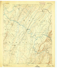
~ Cleveland TN topo map, 1:125000 scale, 30 X 30 Minute, Historical, 1892
Cleveland, Tennessee, USGS topographic map dated 1892.
Includes geographic coordinates (latitude and longitude). This topographic map is suitable for hiking, camping, and exploring, or framing it as a wall map.
Printed on-demand using high resolution imagery, on heavy weight and acid free paper, or alternatively on a variety of synthetic materials.
Topos available on paper, Waterproof, Poly, or Tyvek. Usually shipping rolled, unless combined with other folded maps in one order.
- Product Number: USGS-5338952
- Free digital map download (high-resolution, GeoPDF): Cleveland, Tennessee (file size: 6 MB)
- Map Size: please refer to the dimensions of the GeoPDF map above
- Weight (paper map): ca. 55 grams
- Map Type: POD USGS Topographic Map
- Map Series: HTMC
- Map Verison: Historical
- Cell ID: 65222
- Scan ID: 153504
- Survey Year: 1891
- Datum: Unstated
- Map Projection: Unstated
- Map published by United States Geological Survey
- Map Language: English
- Scanner Resolution: 600 dpi
- Map Cell Name: Cleveland
- Grid size: 30 X 30 Minute
- Date on map: 1892
- Map Scale: 1:125000
- Geographical region: Tennessee, United States
Neighboring Maps:
All neighboring USGS topo maps are available for sale online at a variety of scales.
Spatial coverage:
Topo map Cleveland, Tennessee, covers the geographical area associated the following places:
- Rolling Brook - Benton Station - Benton Springs - Misty Ridge - Benton - North Liberty - Coahulla Ranch - Peach Orchard - Carriage Hills - Red Hill - Shenandoah - Westwood Heights - Laurel Springs - Tasso - Goosetown - Windwood - Sequoia Grove - Monte Carlo Estates - Countryside Village - Poplar Hill - Brewer Addition - Flint Springs - Taylor - Burlington Heights - Chestuee - Georgetown - Folger (historical) - Mount Verd - Big Spring - Union Grove - Austral - Wilson Heights - Seven Cedars - Chable (historical) - Watt Heights - Ball Play - East Cleveland - Sanford - Heritage Hills - Davis Heights - South Mapleton Hills - Goodfield - Fairview - Williamsburg Estates - Alta Vista - Bigsby Creek Estates - Hillsview - Laurel Ridge - Columbus (historical) - Foxfire - Villa Heights - Black Fox - Cedar Spring - Eureka - McDonald - Calhoun - Union - Sylco - Georgetown - Beta - Bryson - Kyle Subdivision - Meadowview - Prospect - Birchwood - Harbor Hills - Nantahala Estates - Charleston - Hills and Dales - Ocoee - Union Grove - Gibson Farm Subdivision - Zion Hill - Camelot - Archville - North Cleveland - Fairview - Wesleyanna - Kingwood Estates - Hidden Valley - Timber Hills - Hopewell Estates - Jacen Gorbett Subdivision - Allen - Housley Addition - Bellefounte - Hambright - Hopewell - Claxton - Arrowhead Point - Ingleside Hill - Waterville - North Etowah - Colonial Estates - Mount Vernon - Bethsalem - Morningside - Eureka Hills - Etowah - Annadale
- Map Area ID: AREA35.535-85-84.5
- Northwest corner Lat/Long code: USGSNW35.5-85
- Northeast corner Lat/Long code: USGSNE35.5-84.5
- Southwest corner Lat/Long code: USGSSW35-85
- Southeast corner Lat/Long code: USGSSE35-84.5
- Northern map edge Latitude: 35.5
- Southern map edge Latitude: 35
- Western map edge Longitude: -85
- Eastern map edge Longitude: -84.5


