
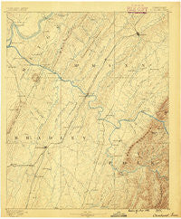
~ Cleveland TN topo map, 1:125000 scale, 30 X 30 Minute, Historical, 1886
Cleveland, Tennessee, USGS topographic map dated 1886.
Includes geographic coordinates (latitude and longitude). This topographic map is suitable for hiking, camping, and exploring, or framing it as a wall map.
Printed on-demand using high resolution imagery, on heavy weight and acid free paper, or alternatively on a variety of synthetic materials.
Topos available on paper, Waterproof, Poly, or Tyvek. Usually shipping rolled, unless combined with other folded maps in one order.
- Product Number: USGS-5338950
- Free digital map download (high-resolution, GeoPDF): Cleveland, Tennessee (file size: 6 MB)
- Map Size: please refer to the dimensions of the GeoPDF map above
- Weight (paper map): ca. 55 grams
- Map Type: POD USGS Topographic Map
- Map Series: HTMC
- Map Verison: Historical
- Cell ID: 65222
- Scan ID: 153503
- Survey Year: 1885
- Datum: Unstated
- Map Projection: Unstated
- Map published by United States Geological Survey
- Map Language: English
- Scanner Resolution: 600 dpi
- Map Cell Name: Cleveland
- Grid size: 30 X 30 Minute
- Date on map: 1886
- Map Scale: 1:125000
- Geographical region: Tennessee, United States
Neighboring Maps:
All neighboring USGS topo maps are available for sale online at a variety of scales.
Spatial coverage:
Topo map Cleveland, Tennessee, covers the geographical area associated the following places:
- Hopewell - Chestuee - Chestuee - Cedar Springs - Hope Acres - Oak Grove - American Heritage - Heritage Hills - Conasauga - Claxton - Rolling Brook - Windwood - Brentwood Estates - McDonald - Grief (historical) - North Liberty - Grady - River Bend Estates - North Cleveland - Balltown - Sanford - Taylor - Laurel Ridge - Linsdale - Homestead Acres - Clear Springs - Suburban Hills - Hutsell - Bent Tree Acres - Clem Jones Heights - Union Grove - Archville - Coahulla Ranch - Wilson Heights - Athens - Climer - Etowah - Blue Springs - East View - Twin Oaks - Wetmore - Oakwood - Mount Harmony - Hambright - Camp Ocoee - Housley Addition - Burlington Heights - Timber Hills - Sherwood Forest - Luskville - Carlock - Meadowview - Nantahala Estates - Green Meadow - Kingwood Estates - Coleman Subdivision - Gibson Farm Subdivision - Hickory Hills - Delano - Spring Creek - Foxfire - Hills and Dales - Dockery - Georgetown - Bethsalem - Coile - Tellico Hills - Northwest Acres - Hidden Valley - Chable (historical) - Double Springs - Shenandoah - Camelot - Varnell Estates - Hooper Acres - Gap Spring - Lockmiller Addition - Seven Cedars - Avalon Heights - Felker - Birchwood - Cayuga Town (historical) - Mount Cumberland - Piney Grove - Misty Ridge - Rolling Hills - Johnston Circle - Etola - Charleston - Georgetown - Freewill - Overbrook - Benton - Beta - Whisperwood - Allen - East View - Lamontville - Williamsburg Estates - Pineland (historical)
- Map Area ID: AREA35.535-85-84.5
- Northwest corner Lat/Long code: USGSNW35.5-85
- Northeast corner Lat/Long code: USGSNE35.5-84.5
- Southwest corner Lat/Long code: USGSSW35-85
- Southeast corner Lat/Long code: USGSSE35-84.5
- Northern map edge Latitude: 35.5
- Southern map edge Latitude: 35
- Western map edge Longitude: -85
- Eastern map edge Longitude: -84.5


