
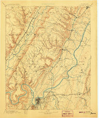
~ Chattanooga TN topo map, 1:125000 scale, 30 X 30 Minute, Historical, 1893, updated 1907
Chattanooga, Tennessee, USGS topographic map dated 1893.
Includes geographic coordinates (latitude and longitude). This topographic map is suitable for hiking, camping, and exploring, or framing it as a wall map.
Printed on-demand using high resolution imagery, on heavy weight and acid free paper, or alternatively on a variety of synthetic materials.
Topos available on paper, Waterproof, Poly, or Tyvek. Usually shipping rolled, unless combined with other folded maps in one order.
- Product Number: USGS-5338940
- Free digital map download (high-resolution, GeoPDF): Chattanooga, Tennessee (file size: 7 MB)
- Map Size: please refer to the dimensions of the GeoPDF map above
- Weight (paper map): ca. 55 grams
- Map Type: POD USGS Topographic Map
- Map Series: HTMC
- Map Verison: Historical
- Cell ID: 65175
- Scan ID: 153500
- Imprint Year: 1907
- Survey Year: 1886
- Datum: Unstated
- Map Projection: Unstated
- Map published by United States Geological Survey
- Map Language: English
- Scanner Resolution: 600 dpi
- Map Cell Name: Chattnooga
- Grid size: 30 X 30 Minute
- Date on map: 1893
- Map Scale: 1:125000
- Geographical region: Tennessee, United States
Neighboring Maps:
All neighboring USGS topo maps are available for sale online at a variety of scales.
Spatial coverage:
Topo map Chattanooga, Tennessee, covers the geographical area associated the following places:
- Elm Hill - Rollingwood - Walden - Hidden Hills Estates - River Oaks - Summertown - Camp Jordan - Melville - Port Serena - Smithtown - Regency Place - Jeffery Acres - Ware Branch - Jersey - Valleyview Subdivision - Engleton Heights - Shady Grove - Pinetree Estates - North Chattanooga - Fort Cheatham - Five Points - Huckleberry - Ridge Lake North - Sequoyah Hills - Sandalwood Village - Northern Hills - Ridge Bay - North Brainerd - Green Hills - Holiday Hills - Farrington Forest - Glenwood - Summit - Lake Village - Deerwood Forest - White Oak - Fountain Village - Highland Manor - Auburn Hills - Concord Heights - Plaza Hills - Austin Farm - Fredonia - Riverside Park - Savannah Bay - Glenmar Hills - Hickory Grove - Shirleyton - Highland Park - Fairview - Dent Acres - Springcrest - Morrison Springs - Radmoor - Ela Wada Terrace - Sale Creek - East Chattanooga - Hixson - Lake Crest - Eastdale - Mineral Park - Grant - Gold Point Estates - Green Acres - Blue Ridge View - Forestwood - Valdeau - Ridgedale - Sulphur Springs - Dowler Heights - Birnam Wood - Harrison - Bartlebaugh Subdivision - Cross Timbers - Chattanooga - Sterling Park - Stoneridge - Bayview - Hampton Woods - Waconda Point - Lakeside Park - Mowbray - Ryall Springs - Edgemont Forest - Country Oaks Estates - North Glen Estates - Crestfield - Holly Heights - Elder Mountain - Laurel Creek - Hillcrest Estates - Cedar Springs - Bluff View - Kings Ridge - Montclair South - Shore Acres - Harrison Bluff - Oak Grove - Riverview - Moon Shadows
- Map Area ID: AREA35.535-85.5-85
- Northwest corner Lat/Long code: USGSNW35.5-85.5
- Northeast corner Lat/Long code: USGSNE35.5-85
- Southwest corner Lat/Long code: USGSSW35-85.5
- Southeast corner Lat/Long code: USGSSE35-85
- Northern map edge Latitude: 35.5
- Southern map edge Latitude: 35
- Western map edge Longitude: -85.5
- Eastern map edge Longitude: -85


