
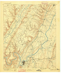
~ Chattanooga TN topo map, 1:125000 scale, 30 X 30 Minute, Historical, 1888
Chattanooga, Tennessee, USGS topographic map dated 1888.
Includes geographic coordinates (latitude and longitude). This topographic map is suitable for hiking, camping, and exploring, or framing it as a wall map.
Printed on-demand using high resolution imagery, on heavy weight and acid free paper, or alternatively on a variety of synthetic materials.
Topos available on paper, Waterproof, Poly, or Tyvek. Usually shipping rolled, unless combined with other folded maps in one order.
- Product Number: USGS-5338930
- Free digital map download (high-resolution, GeoPDF): Chattanooga, Tennessee (file size: 7 MB)
- Map Size: please refer to the dimensions of the GeoPDF map above
- Weight (paper map): ca. 55 grams
- Map Type: POD USGS Topographic Map
- Map Series: HTMC
- Map Verison: Historical
- Cell ID: 65175
- Scan ID: 153495
- Survey Year: 1886
- Datum: Unstated
- Map Projection: Unstated
- Map published by United States Geological Survey
- Map Language: English
- Scanner Resolution: 600 dpi
- Map Cell Name: Chattnooga
- Grid size: 30 X 30 Minute
- Date on map: 1888
- Map Scale: 1:125000
- Geographical region: Tennessee, United States
Neighboring Maps:
All neighboring USGS topo maps are available for sale online at a variety of scales.
Spatial coverage:
Topo map Chattanooga, Tennessee, covers the geographical area associated the following places:
- Murray Hills - Hillsboro Heights - Kings Ridge - Hickory Grove - Auburn Hills - Holiday Hills - Northwoods - Bryan Hill - Laurel Brook - Valleybrook - Spring Valley - Dana Hills - Midvale - Pinetree Estates - Holy Hills - Red Bank - Mile Straight - Pineoak Heights - Hampton Heights - Fairhills - Montclair South - Green Gables Mobile Home Park - Green Hills - North Tower Forest - Hixson - Dallas Hills - Savannah Peninsula - Forest Meade - Knollwood - Green Acres - Hampton Woods - Woodland Heights - Birnam Wood - Farrington Forest - North Glen Estates - Northshore Estates - Royal Oaks - Sequoyah Hills - Tiftonia - Green Cove - Soddy - Collegedale - South Brainerd - East Lake - Norcross Hills - Moon Shadows - Arcadia Shores - Mineral Park - Ponderosa Pines - Eastdale - Fort Cheatham - Oak Hill North - Hickory Hills - Cherokee Woods - Camp Jordan - Prairie Peninsula - Olde Mill - Shirleyton - Lakeside Park - Hughes (historical) - Dowler Heights - Shelton Estates - Shawnee Park - Middle Valley - Opossum Creek Pines - Town Hills - Eastwood Acres - Williamsburg Estates - Acres of Shade Mobile Home Park - Woodmore - Elm Hill - Pineville - Timberlinks - Shore Acres - Tall Oaks Mobile Home Park - West View - Palisades - Austin Farm - Cambridge Estates - Towne Hills - Clearwater Acres - Forest Highlands - Northshore Hills - Summit - Lone Oak - Harbour Woods - Pine Harbor Heights - Marimont - Cloverdale Estates - Lake Hills - Valley Village - Riverchase - Foxwood Estates - Oakhurst - Quail Hollow - Tall Pines Mobile Home Park - Ryall Springs - Gaylan Heights - Alton Park - Poindexter Heights
- Map Area ID: AREA35.535-85.5-85
- Northwest corner Lat/Long code: USGSNW35.5-85.5
- Northeast corner Lat/Long code: USGSNE35.5-85
- Southwest corner Lat/Long code: USGSSW35-85.5
- Southeast corner Lat/Long code: USGSSE35-85
- Northern map edge Latitude: 35.5
- Southern map edge Latitude: 35
- Western map edge Longitude: -85.5
- Eastern map edge Longitude: -85


