
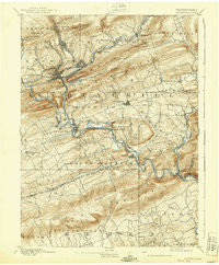
~ Pottsville PA topo map, 1:62500 scale, 15 X 15 Minute, Historical, 1891, updated 1939
Pottsville, Pennsylvania, USGS topographic map dated 1891.
Includes geographic coordinates (latitude and longitude). This topographic map is suitable for hiking, camping, and exploring, or framing it as a wall map.
Printed on-demand using high resolution imagery, on heavy weight and acid free paper, or alternatively on a variety of synthetic materials.
Topos available on paper, Waterproof, Poly, or Tyvek. Usually shipping rolled, unless combined with other folded maps in one order.
- Product Number: USGS-5331292
- Free digital map download (high-resolution, GeoPDF): Pottsville, Pennsylvania (file size: 9 MB)
- Map Size: please refer to the dimensions of the GeoPDF map above
- Weight (paper map): ca. 55 grams
- Map Type: POD USGS Topographic Map
- Map Series: HTMC
- Map Verison: Historical
- Cell ID: 61249
- Scan ID: 221501
- Imprint Year: 1939
- Survey Year: 1889
- Datum: Unstated
- Map Projection: Polyconic
- Map published by United States Geological Survey
- Map Language: English
- Scanner Resolution: 600 dpi
- Map Cell Name: Pottsville
- Grid size: 15 X 15 Minute
- Date on map: 1891
- Map Scale: 1:62500
- Geographical region: Pennsylvania, United States
Neighboring Maps:
All neighboring USGS topo maps are available for sale online at a variety of scales.
Spatial coverage:
Topo map Pottsville, Pennsylvania, covers the geographical area associated the following places:
- Mount Laffee - Moyers - Stony Creek - Hecla - Roeders - New Philadelphia - Silver Creek - Cumbola - Brockton - Glenworth - Jefferson - Duncott - Mount Carbon - Mill Creek - Lake Wynonah - Saint Clair - Deer Lake - Stonemont - Port Carbon - Coal Castle - Landingville - Seltzer - Middleport - Orwigsburg - New Castle - Lorraine - Brommerstown - Beckville - Yoder Heights - Summit Station - Palo Alto - East Mines - Wadesville - Marlin - Kaska - Dark Water - Arnots Addition - Berne - Frisbie - Belmont - Adamsdale - Molino - Drehersville - Shoentown - Jalappa - Auburn - Mechanicsville - Pottsville - Schuylkill Haven - West Hamburg - Friedensburg - McKeansburg - Lewistown - Aucheys - Dieners Hill - Port Clinton - Renningers - Cressona - Shartlesville - Willow Lake
- Map Area ID: AREA40.7540.5-76.25-76
- Northwest corner Lat/Long code: USGSNW40.75-76.25
- Northeast corner Lat/Long code: USGSNE40.75-76
- Southwest corner Lat/Long code: USGSSW40.5-76.25
- Southeast corner Lat/Long code: USGSSE40.5-76
- Northern map edge Latitude: 40.75
- Southern map edge Latitude: 40.5
- Western map edge Longitude: -76.25
- Eastern map edge Longitude: -76


