
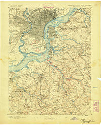
~ Philadelphia PA topo map, 1:62500 scale, 15 X 15 Minute, Historical, 1891
Philadelphia, Pennsylvania, USGS topographic map dated 1891.
Includes geographic coordinates (latitude and longitude). This topographic map is suitable for hiking, camping, and exploring, or framing it as a wall map.
Printed on-demand using high resolution imagery, on heavy weight and acid free paper, or alternatively on a variety of synthetic materials.
Topos available on paper, Waterproof, Poly, or Tyvek. Usually shipping rolled, unless combined with other folded maps in one order.
- Product Number: USGS-5331150
- Free digital map download (high-resolution, GeoPDF): Philadelphia, Pennsylvania (file size: 8 MB)
- Map Size: please refer to the dimensions of the GeoPDF map above
- Weight (paper map): ca. 55 grams
- Map Type: POD USGS Topographic Map
- Map Series: HTMC
- Map Verison: Historical
- Cell ID: 320813
- Scan ID: 169917
- Survey Year: 1888
- Datum: Unstated
- Map Projection: Unstated
- Map published by United States Geological Survey
- Map Language: English
- Scanner Resolution: 600 dpi
- Map Cell Name: Philadelphia
- Grid size: 15 X 15 Minute
- Date on map: 1891
- Map Scale: 1:62500
- Geographical region: Pennsylvania, United States
Neighboring Maps:
All neighboring USGS topo maps are available for sale online at a variety of scales.
Spatial coverage:
Topo map Philadelphia, Pennsylvania, covers the geographical area associated the following places:
- Meadowbrook - Haddon - Blenheim - Creesville - Magnolia - Collingswood - Cherrywood - Colwick - University City - Barrington - Ashland - Overbrook - Almonesson - Good Intent - North Woodbury - Stratford - Elmwood - Greenfield Heights - Somerdale - Hawthorne - Pennsport - Laurel Springs - Stenton - Lawnside - Prossers Mills - Powelton - Village of Glen Oaks - Pennsauken - Haddon Heights - Glendora - Centre City - Kingsessing - Bell Road (historical) - Jordantown - Blackwood - Paradise - Billingsport - Bon Air - Chinatown - Windsor Park - Delair - Merion - Sunset Beach - Cherry Hill - Mill Creek - White Swan Mobile Home Park - Brownsville - Whitman Park - Point Breeze - Thorofare - Audubon Park - Ellisburg - West Haddonfield - Tioga Park - Mount Royal - Rittenhouse - Cobbs Creek - Wynnefield - Leonards - Francisville - Mantua - Blackwood Terrace - Locustwood - Fairview - Passyunk Homes - Oak Valley - Gardenville - Haddon Hills - Morgan Village - Morris - Southwest Center City - Hickstown - Stoys Landing - Yorktown - Ogden - Pavonia - Davisville - Mantua Grove - Delaware Gardens - Lakeland - Parry - Hi-Nella - Terrestria - Colonial Manor - Hurffville - Olde Kensington - Whitman - North Central - Garden Court - Parkers Landing - Parkside - Green-Fields - Jericho - Kensington - Parkside - Lambs Terrace - Osage - Cherry Hill Mall - Schuylkill - Oaklyn
- Map Area ID: AREA4039.75-75.25-75
- Northwest corner Lat/Long code: USGSNW40-75.25
- Northeast corner Lat/Long code: USGSNE40-75
- Southwest corner Lat/Long code: USGSSW39.75-75.25
- Southeast corner Lat/Long code: USGSSE39.75-75
- Northern map edge Latitude: 40
- Southern map edge Latitude: 39.75
- Western map edge Longitude: -75.25
- Eastern map edge Longitude: -75


