
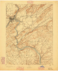
~ Easton PA topo map, 1:62500 scale, 15 X 15 Minute, Historical, 1891, updated 1891
Easton, Pennsylvania, USGS topographic map dated 1891.
Includes geographic coordinates (latitude and longitude). This topographic map is suitable for hiking, camping, and exploring, or framing it as a wall map.
Printed on-demand using high resolution imagery, on heavy weight and acid free paper, or alternatively on a variety of synthetic materials.
Topos available on paper, Waterproof, Poly, or Tyvek. Usually shipping rolled, unless combined with other folded maps in one order.
- Product Number: USGS-5329944
- Free digital map download (high-resolution, GeoPDF): Easton, Pennsylvania (file size: 8 MB)
- Map Size: please refer to the dimensions of the GeoPDF map above
- Weight (paper map): ca. 55 grams
- Map Type: POD USGS Topographic Map
- Map Series: HTMC
- Map Verison: Historical
- Cell ID: 53703
- Scan ID: 167749
- Imprint Year: 1891
- Survey Year: 1888
- Datum: Unstated
- Map Projection: Unstated
- Map published by United States Geological Survey
- Map Language: English
- Scanner Resolution: 600 dpi
- Map Cell Name: Easton
- Grid size: 15 X 15 Minute
- Date on map: 1891
- Map Scale: 1:62500
- Geographical region: Pennsylvania, United States
Neighboring Maps:
All neighboring USGS topo maps are available for sale online at a variety of scales.
Spatial coverage:
Topo map Easton, Pennsylvania, covers the geographical area associated the following places:
- Warren Glen - Mount Joy - Ferndale - Chestnut Ridge Acres - Golden Acres Estates - Phillipsburg - Alpha - Everbreeze Plateau - Chestnut Hill - Pattenburg - Riegelsville - Mutchlertown - Frenchtown - Palmyra - South Easton - Monroe - Easton - Rolling Hill Acres - Still Valley - Ruppletown - Uhlersville (historical) - Kennedys - Uniontown - Stouts - Paxinosa - Durham Hill Farms - Durham - Willow Grove - Everittstown - Carpentersville - Odenweldertown - Baptistown - Gallows Hill - Mount Pleasant - Bucksville Manor - Broadway - Kennedy Mills - Springtown - Coffeetown - Coopersville - West Portal - Kintnersville - Clay Ridge - Valley - Durham Furnace - West Easton - Riegel Ridge - Williamsport - Hughesville - Upper Black Eddy - Harmony - Little York - Narrowsville - Raubsville - Dietrichtown - Lodi - Glendon - Yocum Estates - Zucksville - Bucksville - Spring Mills - Lower Harmony - Jugtown - Revere - Allens Mills - Amsterdam - Lows Hollow - New Village - Uhlerstown - Wilson - Stewartsville - Bloomsbury - Coilton - Milford - Riegelsville - Holland - Erwinna - Port Warren - Shernerville - Swinesburg - Asbury - Browntown - Finesville - Bursonville
- Map Area ID: AREA40.7540.5-75.25-75
- Northwest corner Lat/Long code: USGSNW40.75-75.25
- Northeast corner Lat/Long code: USGSNE40.75-75
- Southwest corner Lat/Long code: USGSSW40.5-75.25
- Southeast corner Lat/Long code: USGSSE40.5-75
- Northern map edge Latitude: 40.75
- Southern map edge Latitude: 40.5
- Western map edge Longitude: -75.25
- Eastern map edge Longitude: -75


