
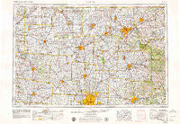
~ Marion OH topo map, 1:250000 scale, 1 X 2 Degree, Historical, 1966, updated 1979
Marion, Ohio, USGS topographic map dated 1966.
Includes geographic coordinates (latitude and longitude). This topographic map is suitable for hiking, camping, and exploring, or framing it as a wall map.
Printed on-demand using high resolution imagery, on heavy weight and acid free paper, or alternatively on a variety of synthetic materials.
Topos available on paper, Waterproof, Poly, or Tyvek. Usually shipping rolled, unless combined with other folded maps in one order.
- Product Number: USGS-5321598
- Free digital map download (high-resolution, GeoPDF): Marion, Ohio (file size: 17 MB)
- Map Size: please refer to the dimensions of the GeoPDF map above
- Weight (paper map): ca. 55 grams
- Map Type: POD USGS Topographic Map
- Map Series: HTMC
- Map Verison: Historical
- Cell ID: 75002
- Scan ID: 225746
- Imprint Year: 1979
- Woodland Tint: Yes
- Aerial Photo Year: 1976
- Edit Year: 1978
- Field Check Year: 1966
- Datum: Unstated
- Map Projection: Transverse Mercator
- Map published by United States Geological Survey
- Map Language: English
- Scanner Resolution: 600 dpi
- Map Cell Name: Marion
- Grid size: 1 X 2 Degree
- Date on map: 1966
- Map Scale: 1:250000
- Geographical region: Ohio, United States
Neighboring Maps:
All neighboring USGS topo maps are available for sale online at a variety of scales.
Spatial coverage:
Topo map Marion, Ohio, covers the geographical area associated the following places:
- Woodland - Five Corners - Woodstone - Hords (historical) - Carrington Place - Westwind - Troyer Mobile Home Park - Royal Coach Estates - Jerome - Knox - Colonial Hills - Meadows At Carson Farms - Hampton Oaks - Shreve - Myers Corners - Carysville - Maybee - Decrow Corners - Tiverton Center - Batemantown - Riverlea - Gretna - Hidden Cove - Johnstown - Olentangy - Tammis Mobile Village - Mount Liberty - Big Springs - Whisper Trace - Upper Sandusky - Waterston - Richland (historical) - Yacht Point Cottage Area - Briarwood Estates Mobile Home Park - Mount Air - Clivdon Mews - Tawa Estates - Minerva Park - Keller Pines - Cherokee - Kellker (historical) - Aaronsburg (historical) - Carefree Estates - Kitzmiller Crossing - Shelby - Carey Mobile Home Park - Jeromesville - Stringtown (historical) - Heritage Lakes - Africa - Pipesville - Rathbone - Stonehenge - Albany Park - Mount Victory - Ashfield Estates Mobile Home Park - Taylor Centre (historical) - Jefferson - Copperwood - Nelson Farms - Morral - Silver Creek - Richlanne Acres - Summerfield - Melco - Kenton - Cordelia - Rain Rock - West Berlin - Pinhook - Treaton - Walton - Riverby Estates - Hassan (historical) - Piatt Meadows - Russell - Havens Corners - Wilshire - Byhalia - Rich Hill - Morehouse (historical) - Reedsburg - Parrott Village - Bucyrus - Centerville - Owl Town (historical) - Waynesburg - Sunbury - Artanna - Village At North Falls - Hickory Woods - Lake Fork - Gast Corner - Spring Mill - Baddow Pass (historical) - Estates At Hoffman Farms - South Park - Big Prairie - Carson Farms - Maple Grove Park
- Map Area ID: AREA4140-84-82
- Northwest corner Lat/Long code: USGSNW41-84
- Northeast corner Lat/Long code: USGSNE41-82
- Southwest corner Lat/Long code: USGSSW40-84
- Southeast corner Lat/Long code: USGSSE40-82
- Northern map edge Latitude: 41
- Southern map edge Latitude: 40
- Western map edge Longitude: -84
- Eastern map edge Longitude: -82


