
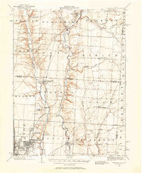
~ Westerville OH topo map, 1:62500 scale, 15 X 15 Minute, Historical, 1902, updated 1958
Westerville, Ohio, USGS topographic map dated 1902.
Includes geographic coordinates (latitude and longitude). This topographic map is suitable for hiking, camping, and exploring, or framing it as a wall map.
Printed on-demand using high resolution imagery, on heavy weight and acid free paper, or alternatively on a variety of synthetic materials.
Topos available on paper, Waterproof, Poly, or Tyvek. Usually shipping rolled, unless combined with other folded maps in one order.
- Product Number: USGS-5321416
- Free digital map download (high-resolution, GeoPDF): Westerville, Ohio (file size: 6 MB)
- Map Size: please refer to the dimensions of the GeoPDF map above
- Weight (paper map): ca. 55 grams
- Map Type: POD USGS Topographic Map
- Map Series: HTMC
- Map Verison: Historical
- Cell ID: 64428
- Scan ID: 226605
- Imprint Year: 1958
- Survey Year: 1902
- Datum: NAD27
- Map Projection: Polyconic
- Map published by United States Geological Survey
- Map Language: English
- Scanner Resolution: 600 dpi
- Map Cell Name: Westerville
- Grid size: 15 X 15 Minute
- Date on map: 1902
- Map Scale: 1:62500
- Geographical region: Ohio, United States
Neighboring Maps:
All neighboring USGS topo maps are available for sale online at a variety of scales.
Spatial coverage:
Topo map Westerville, Ohio, covers the geographical area associated the following places:
- The Shores - Harlem - Willow Brook Crossing - Westerville Estates - Meadows At Lewis Center - Moores Corners - Willow Springs - Mifflinville - The Woods At Bale Kenyon - Mackstown - Hidden Cove - Wildwood Springs (historical) - Walnut Grove Estates - Walker Woods - Colts Neck - Gahanna - Cheshire Woods - Pinecrest - New Albany - Woodstone - Havens Corners - Summerwood - Beech - Blendon Corner - Cheshire - Kitzmiller Crossing - Jefferson Meadows - Piatt Meadows - Estates At Fieldstone - The Woods At Cross Creek - Wonderland (historical) - Wilshire - Parkshore - Pinhook - Vinmar Farms - Grand Oak - Fieldstone - The Woods At Havens Run - Summerfield - Jefferson Estates - Hickory Woods - The Greens At Clarenton - Rome - South Condit - Pickett Place - Parkwood - Walnut Woods - Fenway - Wiveliscombe - Ealy Crossing - Lansdowne - Villas At Hawks Crest - Keller Pines - Clivdon Mews - Bryn Mawr - Running Fox Estates - Center Village - Avonlea - Albany Park - Ovid - Huber Ridge - Sunbury Meadows - Westerville - Arbors At Cheshire - Sheffield Park - New Albany Farms - Cobblestone At The Preserve - Stepping Stone - Ralph (historical) - Clivdon - Africa - Lake of the Woods - Central College - Creekstone - McCammon Estates - Galena - Waverly Place - Hamptons At New Albany - Asbury Heights - Victory Camp - Waterston - Planters Grove - East Linden - Linden - Oakland - Cheshire Cove - Clinton - Sunbury - Mansard Estates - Harbor Pointe - Waggoner Trace - Windale Farms - Parks Mills - Sharon - Gould Park - Hampstead Green - Abbey Knoll - Hampstead Heath - Cedar Run - Royal Elm
- Map Area ID: AREA40.2540-83-82.75
- Northwest corner Lat/Long code: USGSNW40.25-83
- Northeast corner Lat/Long code: USGSNE40.25-82.75
- Southwest corner Lat/Long code: USGSSW40-83
- Southeast corner Lat/Long code: USGSSE40-82.75
- Northern map edge Latitude: 40.25
- Southern map edge Latitude: 40
- Western map edge Longitude: -83
- Eastern map edge Longitude: -82.75


