
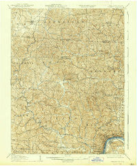
~ Pomeroy OH topo map, 1:62500 scale, 15 X 15 Minute, Historical, 1907, updated 1939
Pomeroy, Ohio, USGS topographic map dated 1907.
Includes geographic coordinates (latitude and longitude). This topographic map is suitable for hiking, camping, and exploring, or framing it as a wall map.
Printed on-demand using high resolution imagery, on heavy weight and acid free paper, or alternatively on a variety of synthetic materials.
Topos available on paper, Waterproof, Poly, or Tyvek. Usually shipping rolled, unless combined with other folded maps in one order.
- Product Number: USGS-5321232
- Free digital map download (high-resolution, GeoPDF): Pomeroy, Ohio (file size: 11 MB)
- Map Size: please refer to the dimensions of the GeoPDF map above
- Weight (paper map): ca. 55 grams
- Map Type: POD USGS Topographic Map
- Map Series: HTMC
- Map Verison: Historical
- Cell ID: 61141
- Scan ID: 227156
- Imprint Year: 1939
- Survey Year: 1905
- Datum: NAD
- Map Projection: Polyconic
- Map published by United States Geological Survey
- Map Language: English
- Scanner Resolution: 600 dpi
- Map Cell Name: Pomeroy
- Grid size: 15 X 15 Minute
- Date on map: 1907
- Map Scale: 1:62500
- Geographical region: Ohio, United States
Neighboring Maps:
All neighboring USGS topo maps are available for sale online at a variety of scales.
Spatial coverage:
Topo map Pomeroy, Ohio, covers the geographical area associated the following places:
- Lima - Carpenter - Browntown - Horner Hill - Pratts Fork - Welsh - Thomas Village - Dexter - Harrisonville - Pageville - Rutland - Midway - Kerrs Run - Langsville - Valley Ford - Middleport - Darwin - Pomeroy - Pleasanton - Dyesville - Albany - Burlingham - Hanesville - Martinsburg (historical) - Bradbury - Clifton - Bunker Hill (historical) - Chase - Buckhorn (historical) - Rock Springs - Lincoln Heights - Snowville - Mason - Wolfpen - Kingsbury - Shade
- Map Area ID: AREA39.2539-82.25-82
- Northwest corner Lat/Long code: USGSNW39.25-82.25
- Northeast corner Lat/Long code: USGSNE39.25-82
- Southwest corner Lat/Long code: USGSSW39-82.25
- Southeast corner Lat/Long code: USGSSE39-82
- Northern map edge Latitude: 39.25
- Southern map edge Latitude: 39
- Western map edge Longitude: -82.25
- Eastern map edge Longitude: -82


