
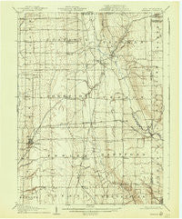
~ Kinsman OH topo map, 1:62500 scale, 15 X 15 Minute, Historical, 1907, updated 1940
Kinsman, Ohio, USGS topographic map dated 1907.
Includes geographic coordinates (latitude and longitude). This topographic map is suitable for hiking, camping, and exploring, or framing it as a wall map.
Printed on-demand using high resolution imagery, on heavy weight and acid free paper, or alternatively on a variety of synthetic materials.
Topos available on paper, Waterproof, Poly, or Tyvek. Usually shipping rolled, unless combined with other folded maps in one order.
- Product Number: USGS-5320998
- Free digital map download (high-resolution, GeoPDF): Kinsman, Ohio (file size: 6 MB)
- Map Size: please refer to the dimensions of the GeoPDF map above
- Weight (paper map): ca. 55 grams
- Map Type: POD USGS Topographic Map
- Map Series: HTMC
- Map Verison: Historical
- Cell ID: 56221
- Scan ID: 225508
- Imprint Year: 1940
- Survey Year: 1905
- Datum: NAD
- Map Projection: Polyconic
- Map published by United States Geological Survey
- Map Language: English
- Scanner Resolution: 600 dpi
- Map Cell Name: Kinsman
- Grid size: 15 X 15 Minute
- Date on map: 1907
- Map Scale: 1:62500
- Geographical region: Ohio, United States
Neighboring Maps:
All neighboring USGS topo maps are available for sale online at a variety of scales.
Spatial coverage:
Topo map Kinsman, Ohio, covers the geographical area associated the following places:
- Burghill - Five Points - Weldon - Orangeville - Corinth - Stanhope - Fowler - Kenilworth - Kinsman - Dlworth - Superior (historical) - Rices Mills - Venice Heights - Dewey (historical) - Howland Center - Cornelion - King Corners - Lobaugh - Tyrrell - Yankee Lake - Nutwood - Triumph - Fowler Mobile Home Court - Four Seasons Mobile Home Park - Cortland - Mecca - Gustavus - Greene - Vernon - Johnston - Hartford - Antietam (historical) - Latimer - Brockway (historical) - York (historical) - Farmdale - Barclay
- Map Area ID: AREA41.541.25-80.75-80.5
- Northwest corner Lat/Long code: USGSNW41.5-80.75
- Northeast corner Lat/Long code: USGSNE41.5-80.5
- Southwest corner Lat/Long code: USGSSW41.25-80.75
- Southeast corner Lat/Long code: USGSSE41.25-80.5
- Northern map edge Latitude: 41.5
- Southern map edge Latitude: 41.25
- Western map edge Longitude: -80.75
- Eastern map edge Longitude: -80.5


