
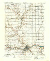
~ Defiance OH topo map, 1:62500 scale, 15 X 15 Minute, Historical, 1907, updated 1960
Defiance, Ohio, USGS topographic map dated 1907.
Includes geographic coordinates (latitude and longitude). This topographic map is suitable for hiking, camping, and exploring, or framing it as a wall map.
Printed on-demand using high resolution imagery, on heavy weight and acid free paper, or alternatively on a variety of synthetic materials.
Topos available on paper, Waterproof, Poly, or Tyvek. Usually shipping rolled, unless combined with other folded maps in one order.
- Product Number: USGS-5320832
- Free digital map download (high-resolution, GeoPDF): Defiance, Ohio (file size: 5 MB)
- Map Size: please refer to the dimensions of the GeoPDF map above
- Weight (paper map): ca. 55 grams
- Map Type: POD USGS Topographic Map
- Map Series: HTMC
- Map Verison: Historical
- Cell ID: 53307
- Scan ID: 224655
- Imprint Year: 1960
- Survey Year: 1907
- Datum: NAD
- Map Projection: Polyconic
- Map published by United States Geological Survey
- Map Language: English
- Scanner Resolution: 600 dpi
- Map Cell Name: Defiance
- Grid size: 15 X 15 Minute
- Date on map: 1907
- Map Scale: 1:62500
- Geographical region: Ohio, United States
Neighboring Maps:
All neighboring USGS topo maps are available for sale online at a variety of scales.
Spatial coverage:
Topo map Defiance, Ohio, covers the geographical area associated the following places:
- Independence - Lakeland Woods Estates - Short Trailer Park - Green Acres Mobile Home Park - North Town Estates - Ridgeville Corners - Hickory Hills - Domerville (historical) - Defiance - Cooks Rolling Hills - Fox Chase - Adams Ridge - Brunersburg - Spring Meadows - Coys Subdivision - Williamstown - Millers Rolling Hills Estates - Wilna - Midway (historical) - Bohlmanns Trailer Park - Ashwood (historical) - Jewell - Evansport - Shaffers Acres - Riggs Subdivision - Promised Land Subdivision - Hohenberger Trailer Court - Glenburg (historical)
- Map Area ID: AREA41.541.25-84.5-84.25
- Northwest corner Lat/Long code: USGSNW41.5-84.5
- Northeast corner Lat/Long code: USGSNE41.5-84.25
- Southwest corner Lat/Long code: USGSSW41.25-84.5
- Southeast corner Lat/Long code: USGSSE41.25-84.25
- Northern map edge Latitude: 41.5
- Southern map edge Latitude: 41.25
- Western map edge Longitude: -84.5
- Eastern map edge Longitude: -84.25


