
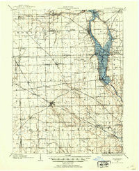
~ Brookville OH topo map, 1:62500 scale, 15 X 15 Minute, Historical, 1905, updated 1953
Brookville, Ohio, USGS topographic map dated 1905.
Includes geographic coordinates (latitude and longitude). This topographic map is suitable for hiking, camping, and exploring, or framing it as a wall map.
Printed on-demand using high resolution imagery, on heavy weight and acid free paper, or alternatively on a variety of synthetic materials.
Topos available on paper, Waterproof, Poly, or Tyvek. Usually shipping rolled, unless combined with other folded maps in one order.
- Product Number: USGS-5320702
- Free digital map download (high-resolution, GeoPDF): Brookville, Ohio (file size: 6 MB)
- Map Size: please refer to the dimensions of the GeoPDF map above
- Weight (paper map): ca. 55 grams
- Map Type: POD USGS Topographic Map
- Map Series: HTMC
- Map Verison: Historical
- Cell ID: 51833
- Scan ID: 224204
- Imprint Year: 1953
- Edit Year: 1953
- Survey Year: 1905
- Datum: Unstated
- Map Projection: Polyconic
- Map published by United States Geological Survey
- Map Language: English
- Scanner Resolution: 600 dpi
- Map Cell Name: Brookville
- Grid size: 15 X 15 Minute
- Date on map: 1905
- Map Scale: 1:62500
- Geographical region: Ohio, United States
Neighboring Maps:
All neighboring USGS topo maps are available for sale online at a variety of scales.
Spatial coverage:
Topo map Brookville, Ohio, covers the geographical area associated the following places:
- Pyrmont - Catalpa Grove Mobile Home Park - Residence Park - Crown Point - Stillwater Junction - Taylorsburg - Union - Sixmile - County Line (historical) - Airhill - Nashville - Deerpark Village - Northview - Hays Corner - Swanktown - Pinebrook Estates - Post Town - Laura - Brookville Lakes Estates - Frederick - Phillipsburg - Trotwood - Kessler - Pitsburg - Clayton - Fort McKinley - Little York - Kreitzer Corner - Happy Corners - Brookville - Amity - Dodson - Stringtown - Pinchtown (historical) - West Milton - Garland - Morgan Place - Pigeye - Potsdam - Irvington - Kinsey - Little Richmond - Main Meadows Mobile Home Park - Englewood - Bachman - Ludlow Falls - Regina Heights - Midway - Five Points - Wengerlawn - Verona - Arlington
- Map Area ID: AREA4039.75-84.5-84.25
- Northwest corner Lat/Long code: USGSNW40-84.5
- Northeast corner Lat/Long code: USGSNE40-84.25
- Southwest corner Lat/Long code: USGSSW39.75-84.5
- Southeast corner Lat/Long code: USGSSE39.75-84.25
- Northern map edge Latitude: 40
- Southern map edge Latitude: 39.75
- Western map edge Longitude: -84.5
- Eastern map edge Longitude: -84.25


