
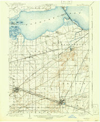
~ Bellevue OH topo map, 1:62500 scale, 15 X 15 Minute, Historical, 1903, updated 1942
Bellevue, Ohio, USGS topographic map dated 1903.
Includes geographic coordinates (latitude and longitude). This topographic map is suitable for hiking, camping, and exploring, or framing it as a wall map.
Printed on-demand using high resolution imagery, on heavy weight and acid free paper, or alternatively on a variety of synthetic materials.
Topos available on paper, Waterproof, Poly, or Tyvek. Usually shipping rolled, unless combined with other folded maps in one order.
- Product Number: USGS-5320682
- Free digital map download (high-resolution, GeoPDF): Bellevue, Ohio (file size: 6 MB)
- Map Size: please refer to the dimensions of the GeoPDF map above
- Weight (paper map): ca. 55 grams
- Map Type: POD USGS Topographic Map
- Map Series: HTMC
- Map Verison: Historical
- Cell ID: 51145
- Scan ID: 224060
- Imprint Year: 1942
- Survey Year: 1901
- Datum: Unstated
- Map Projection: Polyconic
- Map published by United States Geological Survey
- Map Language: English
- Scanner Resolution: 600 dpi
- Map Cell Name: Bellevue
- Grid size: 15 X 15 Minute
- Date on map: 1903
- Map Scale: 1:62500
- Geographical region: Ohio, United States
Neighboring Maps:
All neighboring USGS topo maps are available for sale online at a variety of scales.
Spatial coverage:
Topo map Bellevue, Ohio, covers the geographical area associated the following places:
- Mobile Home Estates - Whitmore - Bay View - Weyers - Springbrook - Sand Hill - Lyme (historical) - Whites Landing - Westview Estates - Gypsum - Wales Corners - Hickory Grove - Mount Carmel - Anchor Mobile Home Park - Bellevue - Danbury - York - Castalia - Clyde - Mount Pleasant - Edgewater Estates - Crystal Rock - Cherry Knoll Mobile Park - Bayshore - Galetown - Baywater Estates - Sunset Harbor - Parkertown - Colby - Shady Acres - Venice - Bay View - Strongs Ridge - Vickery - Teemes (historical)
- Map Area ID: AREA41.541.25-83-82.75
- Northwest corner Lat/Long code: USGSNW41.5-83
- Northeast corner Lat/Long code: USGSNE41.5-82.75
- Southwest corner Lat/Long code: USGSSW41.25-83
- Southeast corner Lat/Long code: USGSSE41.25-82.75
- Northern map edge Latitude: 41.5
- Southern map edge Latitude: 41.25
- Western map edge Longitude: -83
- Eastern map edge Longitude: -82.75


