
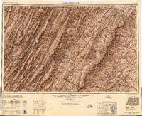
~ Charlottesville VA topo map, 1:250000 scale, 1 X 2 Degree, Historical, 1949
Charlottesville, Virginia, USGS topographic map dated 1949.
Includes geographic coordinates (latitude and longitude). This topographic map is suitable for hiking, camping, and exploring, or framing it as a wall map.
Printed on-demand using high resolution imagery, on heavy weight and acid free paper, or alternatively on a variety of synthetic materials.
Topos available on paper, Waterproof, Poly, or Tyvek. Usually shipping rolled, unless combined with other folded maps in one order.
- Product Number: USGS-5304188
- Free digital map download (high-resolution, GeoPDF): Charlottesville, Virginia (file size: 17 MB)
- Map Size: please refer to the dimensions of the GeoPDF map above
- Weight (paper map): ca. 55 grams
- Map Type: POD USGS Topographic Map
- Map Series: HTMC
- Map Verison: Historical
- Cell ID: 68712
- Scan ID: 189239
- Aerial Photo Year: 1945
- Datum: NAD27
- Map Projection: Transverse Mercator
- Shaded Relief map: Yes
- Map published by United States Army Corps of Engineers
- Map published by United States Army
- Map Language: English
- Scanner Resolution: 600 dpi
- Map Cell Name: Charlottesville
- Grid size: 1 X 2 Degree
- Date on map: 1949
- Map Scale: 1:250000
- Geographical region: Virginia, United States
Neighboring Maps:
All neighboring USGS topo maps are available for sale online at a variety of scales.
Spatial coverage:
Topo map Charlottesville, Virginia, covers the geographical area associated the following places:
- Harperton - Shenandoah - Rotherwood - Rio Heights - Mauzy - Northfields - Ednam Village - Clover Hill - Bruxton - Hiser (historical) - Key West - Rocky Bar - Cresthill - Naples (historical) - Zigler - Hardscrabble - Seemly (historical) - Limeton - Oak Hill - Maurertown - Piedmont - Blueridge Forest - Scrabble - Flint - Lydia - Swannanoa - Wilson Heights - Highland Park - Riverton - Millington - Cherry Grove - Trimble - Wakefield - Skyland Estates - Zirkle - Almond (historical) - Roman - Dungadin Heights - Albano - Mountain Grove - Mountain Laurel - Montpelier Station - Vanderpool - Rileyville - Steiner (historical) - Georgetown - Burtonville - Arbor Park - Parkview - Gilman - Boyer - Luray - Perlytown (historical) - Haywood - Rockland - Rio - Crossroads - Sherwood Farms - Green Springs - Mooretown - Middlebrook - Merrymount - Raintree - West Junior - Doe Hill - Waylandsburg - Canfield - The Pines - Shenandoah Farms - Brookside - Waldrop - Airport Acres - West Warm Springs - Goods Mill - Eastham - Clearview Meadows - Chester Gap - Salem - Medlock - Alpine - Camellia Garden - McClung - Quicks Mill - Wheeler (historical) - Harrell Corner - Augusta Springs - Shadwell Mountain - Moyers - Front Royal Junction - West End - Old Somerset - Fairview Acres - Lasley (historical) - Evenwood - Bellair - Coffmantown - Chinquapin - Mountain View - Westover Hills - Alonzaville
- Map Area ID: AREA3938-80-78
- Northwest corner Lat/Long code: USGSNW39-80
- Northeast corner Lat/Long code: USGSNE39-78
- Southwest corner Lat/Long code: USGSSW38-80
- Southeast corner Lat/Long code: USGSSE38-78
- Northern map edge Latitude: 39
- Southern map edge Latitude: 38
- Western map edge Longitude: -80
- Eastern map edge Longitude: -78


