
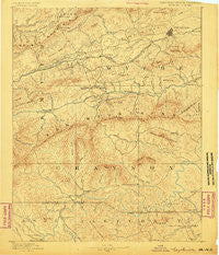
~ Wytheville VA topo map, 1:125000 scale, 30 X 30 Minute, Historical, 1889
Wytheville, Virginia, USGS topographic map dated 1889.
Includes geographic coordinates (latitude and longitude). This topographic map is suitable for hiking, camping, and exploring, or framing it as a wall map.
Printed on-demand using high resolution imagery, on heavy weight and acid free paper, or alternatively on a variety of synthetic materials.
Topos available on paper, Waterproof, Poly, or Tyvek. Usually shipping rolled, unless combined with other folded maps in one order.
- Product Number: USGS-5304172
- Free digital map download (high-resolution, GeoPDF): Wytheville, Virginia (file size: 9 MB)
- Map Size: please refer to the dimensions of the GeoPDF map above
- Weight (paper map): ca. 55 grams
- Map Type: POD USGS Topographic Map
- Map Series: HTMC
- Map Verison: Historical
- Cell ID: 66980
- Scan ID: 189220
- Survey Year: 1888
- Datum: Unstated
- Map Projection: Unstated
- Map published by United States Geological Survey
- Map Language: English
- Scanner Resolution: 600 dpi
- Map Cell Name: Wytheville
- Grid size: 30 X 30 Minute
- Date on map: 1889
- Map Scale: 1:125000
- Geographical region: Virginia, United States
Neighboring Maps:
All neighboring USGS topo maps are available for sale online at a variety of scales.
Spatial coverage:
Topo map Wytheville, Virginia, covers the geographical area associated the following places:
- Slabtown - Baywood - Spring Valley - Peach Bottom - Roberts Mill - Crockett - Beaver - Catron (historical) - Bennington Mill - Barton Crossroad - Chestnut Hill - Collier - Cline - New Haven - Wilson - Kegleys - Topia - Groseclose - Atkins - Nebo - Fairview - Stratford - Independence - Eagle (historical) - West Piney - Grant - Speedwell - Summit - Comers Rock - Kent - Sessex - Favonia - Fairwood - Petunia - Sturgills - Attoway - Furnace Hill - Flat Ridge - Fallville - Crowgeys - Kings Creek - Clito Mill - Blacklick - Groseclose - Helton - Cedar Springs - Edwards Crossroads - Carsonville - Oak Hill - Staley Crossroads - Mouth of Wilson - Noble Furnace - Twin Oaks - Bridle Creek - Wytheville - Sparta - Fox - Stones Mill - Stringtown - Willard - Henley - Cripple Creek - Blessing - Shupe - Rural Retreat - Fairview - Lower Elk Creek - Eagle Furnace - Weavers Ford - Mill Creek - Grubb - Trout Dale - Piney Creek - Grassy Creek - Chestnut Grove - Turkey Fork - Shiloh - Copenhavers - Murpheyville - Shady Grove - Huddle - Hooker - Mount Zion - Rowe Crossroads - Volney - Vox - Blevins Crossroads - Sutherland - Mount Carmel - Stinson - Elk Creek - Rugby - Sugar Grove - Hildreths House - Groseclose Store - Musser - Kindrick - Crumpler - Amelia - Riverside
- Map Area ID: AREA3736.5-81.5-81
- Northwest corner Lat/Long code: USGSNW37-81.5
- Northeast corner Lat/Long code: USGSNE37-81
- Southwest corner Lat/Long code: USGSSW36.5-81.5
- Southeast corner Lat/Long code: USGSSE36.5-81
- Northern map edge Latitude: 37
- Southern map edge Latitude: 36.5
- Western map edge Longitude: -81.5
- Eastern map edge Longitude: -81


