
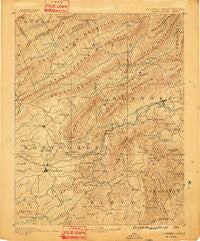
~ Christiansburg VA topo map, 1:125000 scale, 30 X 30 Minute, Historical, 1890, updated 1891
Christiansburg, Virginia, USGS topographic map dated 1890.
Includes geographic coordinates (latitude and longitude). This topographic map is suitable for hiking, camping, and exploring, or framing it as a wall map.
Printed on-demand using high resolution imagery, on heavy weight and acid free paper, or alternatively on a variety of synthetic materials.
Topos available on paper, Waterproof, Poly, or Tyvek. Usually shipping rolled, unless combined with other folded maps in one order.
- Product Number: USGS-5303790
- Free digital map download (high-resolution, GeoPDF): Christiansburg, Virginia (file size: 9 MB)
- Map Size: please refer to the dimensions of the GeoPDF map above
- Weight (paper map): ca. 55 grams
- Map Type: POD USGS Topographic Map
- Map Series: HTMC
- Map Verison: Historical
- Cell ID: 65201
- Scan ID: 188893
- Imprint Year: 1891
- Survey Year: 1887
- Datum: Unstated
- Map Projection: Unstated
- Map published by United States Geological Survey
- Map Language: English
- Scanner Resolution: 600 dpi
- Map Cell Name: Christiansburg
- Grid size: 30 X 30 Minute
- Date on map: 1890
- Map Scale: 1:125000
- Geographical region: Virginia, United States
Neighboring Maps:
All neighboring USGS topo maps are available for sale online at a variety of scales.
Spatial coverage:
Topo map Christiansburg, Virginia, covers the geographical area associated the following places:
- Bennetts Mill - Pilot - Loch Haven - Mount Tabor - Hillview Park - Roanoke Red Sulphur Springs - Carlton Park - Maggie - Mountain Top Estates - Oak Manor - Woodlawn - Berryfield - Bangs (historical) - Robin Hood Park - Walnut Grove - Pine Grove - Mountain View - Airview Court - Farmview - Beverly Heights - Hillcrest Heights - Diamond Pointe - Brookwood - Boxwood Hills - Catawba - Andrew Lewis - Stratford Park - Sugar Grove - Medmont Lake - Orchard View - Forest Lawn - Gunn - Kenwick Place - Bonvue Heights - Salem Village Trailer Park - Hill Subdivision - Wiley Court - Windsor Park - Mission Hills - Heidelberg Estates - Piedmont - Town and Country Estates - Lafayette - Shenandoah - Penn Forest - Evans Hill - Willow Green - Dunton Addition - Wedgewood Forest - Midway Heights - Mountain View Estates - Mount Regis Heights - Maylin Hills - Merrimac - Castle Rock Farms - Fagg - Crestmoor Court - Rainbow Ridge - Manchester Court - Craig Mountain - Luther Park - Green Hill - Briar Ridge - Rosecrest - Mitchell - Windsor Estates - Belmont - Poages Mill Estates - Salem Heights - Elliston - Highfields - Western Hills - Shadeland Addition - West Club Forest - Meadowview - Brightwood Manor - Bear Rock - Melody Acres - Washington Heights - East Park Addition - Knollwood - Kessler Park - Southgate - Cherokee Hills - Sugar Loaf Estates - Oak Ridge - Sundance Village - Reesedale - Woodside Park - Meadow Wood Estates - Westland - Farmington Lake - The Orchard - Evergreen - Hemlock - McBryde Village - Ingleside - Dillons Mill - Johnson Heights - Tinker (historical)
- Map Area ID: AREA37.537-80.5-80
- Northwest corner Lat/Long code: USGSNW37.5-80.5
- Northeast corner Lat/Long code: USGSNE37.5-80
- Southwest corner Lat/Long code: USGSSW37-80.5
- Southeast corner Lat/Long code: USGSSE37-80
- Northern map edge Latitude: 37.5
- Southern map edge Latitude: 37
- Western map edge Longitude: -80.5
- Eastern map edge Longitude: -80


