
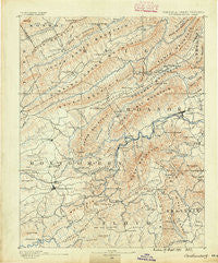
~ Christiansburg VA topo map, 1:125000 scale, 30 X 30 Minute, Historical, 1890
Christiansburg, Virginia, USGS topographic map dated 1890.
Includes geographic coordinates (latitude and longitude). This topographic map is suitable for hiking, camping, and exploring, or framing it as a wall map.
Printed on-demand using high resolution imagery, on heavy weight and acid free paper, or alternatively on a variety of synthetic materials.
Topos available on paper, Waterproof, Poly, or Tyvek. Usually shipping rolled, unless combined with other folded maps in one order.
- Product Number: USGS-5303788
- Free digital map download (high-resolution, GeoPDF): Christiansburg, Virginia (file size: 9 MB)
- Map Size: please refer to the dimensions of the GeoPDF map above
- Weight (paper map): ca. 55 grams
- Map Type: POD USGS Topographic Map
- Map Series: HTMC
- Map Verison: Historical
- Cell ID: 65201
- Scan ID: 188892
- Survey Year: 1887
- Datum: Unstated
- Map Projection: Unstated
- Map published by United States Geological Survey
- Map Language: English
- Scanner Resolution: 600 dpi
- Map Cell Name: Christiansburg
- Grid size: 30 X 30 Minute
- Date on map: 1890
- Map Scale: 1:125000
- Geographical region: Virginia, United States
Neighboring Maps:
All neighboring USGS topo maps are available for sale online at a variety of scales.
Spatial coverage:
Topo map Christiansburg, Virginia, covers the geographical area associated the following places:
- Ironto - Kimball Acres - Whitefield - Sugar Grove - Moomaw (historical) - Farmington Lake - Newcomb Heights - Reesedale - Bear Rock - Wilmont Farms - DeHart Subdivision - Eton Hill - Woodmont Manor - Preston Forest - Simpsons - Roland Terrace - Lake Spring - Hillcrest Heights - Canterbury - Edgelawn - Suburban Hills - Salem - Clearview Heights - Bridlewood - Valley Mill - Spring Garden - Mountain Heights - Lafayette - Oak Ridge - Dawnwood Forest - Cumberland Forest - Spangler - Airpoint - Hemlock - Beacon Hills - Airport Acres - Wyndale - Craig Springs - Hanging Rock - Blackwood - Stroubles Mill - Woodbridge - Orchard Heights - Snidow Heights - City View Heights - Adam Acres - Bennett Springs - Windsor Estates - Airview Court - Green Hill Terrace - Barrister Estates - Fort Lewis Terrace - Holly Ridge - Morwanda Park - Keslers Mill - Berryfield - Rogers - Glen Forest - Pine Bluff - Stonegate - Apperson Park - Woodbine - Laurel Ridge - Riverlee - Chimney Hill Estates - Belle Aire - Hans Meadow - Poages Mill Estates - Boulevard Estates - Farmingdale - Arlington Hills - Marvin Garden Subdivision - Plainview - Hemlock Hills - Taryn Hills - Glenvar - Blacksburg - Vicker - Palmer Park - Brightwood Manor - Looney - Montclair Estates - Brookwood - Washington Heights - Manwaring Manor - Highview Terrace - Deep Dell - Dillons Mill - Westland - Scenic Hills - Patrick Henry Place - Waiteville - The Orchard - Wedgewood Forest - Brush Harbor - Stonegate - Forest Lawn - Cherokee Hills - Manchester Court - Johnson Heights
- Map Area ID: AREA37.537-80.5-80
- Northwest corner Lat/Long code: USGSNW37.5-80.5
- Northeast corner Lat/Long code: USGSNE37.5-80
- Southwest corner Lat/Long code: USGSSW37-80.5
- Southeast corner Lat/Long code: USGSSE37-80
- Northern map edge Latitude: 37.5
- Southern map edge Latitude: 37
- Western map edge Longitude: -80.5
- Eastern map edge Longitude: -80


