
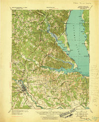
~ Stafford VA topo map, 1:62500 scale, 15 X 15 Minute, Historical, 1931
Stafford, Virginia, USGS topographic map dated 1931.
Includes geographic coordinates (latitude and longitude). This topographic map is suitable for hiking, camping, and exploring, or framing it as a wall map.
Printed on-demand using high resolution imagery, on heavy weight and acid free paper, or alternatively on a variety of synthetic materials.
Topos available on paper, Waterproof, Poly, or Tyvek. Usually shipping rolled, unless combined with other folded maps in one order.
- Product Number: USGS-5303416
- Free digital map download (high-resolution, GeoPDF): Stafford, Virginia (file size: 9 MB)
- Map Size: please refer to the dimensions of the GeoPDF map above
- Weight (paper map): ca. 55 grams
- Map Type: POD USGS Topographic Map
- Map Series: HTMC
- Map Verison: Historical
- Cell ID: 62900
- Scan ID: 188591
- Woodland Tint: Yes
- Datum: NAD
- Map Projection: Polyconic
- Map published by United States Army Corps of Engineers
- Map Language: English
- Scanner Resolution: 600 dpi
- Map Cell Name: Stafford
- Grid size: 15 X 15 Minute
- Date on map: 1931
- Map Scale: 1:62500
- Geographical region: Virginia, United States
Neighboring Maps:
All neighboring USGS topo maps are available for sale online at a variety of scales.
Spatial coverage:
Topo map Stafford, Virginia, covers the geographical area associated the following places:
- Dahlgren Junction (historical) - Fourmile Fork - Will-More - Chatham Landing - Potomac Hills - Clarion Woods - White Oak Hills - Bel Air - Sycamore Ridge - Vintage Oaks - Beverly Forest - Debruyn - Foreston Woods North - Country Ridge - River Bend - Graninger Mobile Home Park - Braehead Woods - The Holly Woods - Ingleside - Stratford Place - Fines Corner - Highland Homes - Magnolia Woods - Courts at Stafford - Sealston - Briarwood Estates - Apple Grove - Northridge - Perry Farms - Sylvania Heights - Falmouth Bridge - Woodland - Bald Eagle Hills - Bells Run - Victoria Woods - Chatham Farms - Cabin Creekwood - Blythedale - Grace Shelton Family Subdivision - Hazel Hill - Olde Forge - Stallings - Graninger - Brentwood Estates - Meadowood Village - Highpointe - Poplar Hills - Biscoe - Sullivan - Belle Air Heights - Wallace Farms - Yendor Landing - Georgetown East - Aquia Beach - Greenridge - Grafton Village - Ferry Road - Sunnyside Division - Arbor Glen - Daffan - Widewater Beach - Docstone Woods - Rollinswood South - Woodlanding Village - Misty Forest - Walnut Hill - Stowe of Amyclae - Leeland Creek Estates - Port Aquia - Widewater Village at Stafford - Stones Corner - Oakbrooke - Lyons Den - Cox Corner - New Hope Estates - Will Morgan Farm - Settlers Landing - Burnside - Fredericksburg - Decatur (historical) - The Hills of Potomac Creek - Bexley Manor - Mount Pleasant Estates - Argyle Heights - Deacon Woods - Stafford Mews - Greenstreet Mobile Home Park - England Run North - Knotsmythes Landing - Onville (historical) - Somerset Landing - Colbert Walker Estates - Hampstead Village - Norman Estates - Mount Ringold Farm - Fritters Lane - Freds Corner - Hart Division of Little Falls - Joseph Sullivan Estates - Eastern View
- Map Area ID: AREA38.538.25-77.5-77.25
- Northwest corner Lat/Long code: USGSNW38.5-77.5
- Northeast corner Lat/Long code: USGSNE38.5-77.25
- Southwest corner Lat/Long code: USGSSW38.25-77.5
- Southeast corner Lat/Long code: USGSSE38.25-77.25
- Northern map edge Latitude: 38.5
- Southern map edge Latitude: 38.25
- Western map edge Longitude: -77.5
- Eastern map edge Longitude: -77.25


