
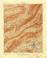
~ Salem VA topo map, 1:62500 scale, 15 X 15 Minute, Historical, 1932, updated 1945
Salem, Virginia, USGS topographic map dated 1932.
Includes geographic coordinates (latitude and longitude). This topographic map is suitable for hiking, camping, and exploring, or framing it as a wall map.
Printed on-demand using high resolution imagery, on heavy weight and acid free paper, or alternatively on a variety of synthetic materials.
Topos available on paper, Waterproof, Poly, or Tyvek. Usually shipping rolled, unless combined with other folded maps in one order.
- Product Number: USGS-5303372
- Free digital map download (high-resolution, GeoPDF): Salem, Virginia (file size: 12 MB)
- Map Size: please refer to the dimensions of the GeoPDF map above
- Weight (paper map): ca. 55 grams
- Map Type: POD USGS Topographic Map
- Map Series: HTMC
- Map Verison: Historical
- Cell ID: 62027
- Scan ID: 188563
- Imprint Year: 1945
- Survey Year: 1929
- Datum: NAD
- Map Projection: Polyconic
- Map published by United States Geological Survey
- Map Language: English
- Scanner Resolution: 600 dpi
- Map Cell Name: Salem
- Grid size: 15 X 15 Minute
- Date on map: 1932
- Map Scale: 1:62500
- Geographical region: Virginia, United States
Neighboring Maps:
All neighboring USGS topo maps are available for sale online at a variety of scales.
Spatial coverage:
Topo map Salem, Virginia, covers the geographical area associated the following places:
- Honeysuckle Bluff - Westfield - Lake View - Hidden Acres - Ridgewood Heights - Country Club Estates - Riverside Estates - Mill Road Park - Riverlee - Hickory Hill - Moomaw (historical) - Locust Grove Park - Spangler - Wilmont Farms - Catawba - Knollwood - Lee Hy Park - Tinker (historical) - Orchard Court - Palmer Park - Talking Leaves - West View Terrace - Bonvue Heights - Cherokee Hills - Maylin Hills - Glenvar Heights - Glen Forest - Panorama Heights - Hanging Rock - Keslers Mill - West Chester - Medmont Lake - Montclair Estates - Palmer - Stonewall Forest - Circle Terrace - Cherry Hill - North Lakes - Dawnwood Forest - Oak Ridge - Southside Hills - Vermont Heights - Hockman - Whitefield - Fairfield - Fairway Forest - Forest Lawn - Panorama Court - Karen Hills - Hill Subdivision - Woodlawn - Willow Green - Bellevue Park - Morwanda Park - Orchard Heights - Moneiro - Beacon Hills - Oak Park - Roanoke Red Sulphur Springs - Pine Oak Heights - Farmingdale - Glenvar East - Wiley Court - Kimball Acres - Summit Hills - Chimney Hill Estates - Abbott - Evans Hill - Washington Heights - King - Hillcrest Heights - Southdowns - Heidelberg Estates - Glenvar - Glendale - Mason Cove - Rolling Woods - Deep Dell - Dropmore - Crestmoor Court - Medley - Kerner - Hemlock Hills - Spruce Hill - Windsor Hills - Green Hill - Westchester Court - Stonegate - Oak Grove Farms - Middleton Gardens - Pine Bluff - Dale Court - Lake Spring Land - Carlton Park - Spring Garden - Lee-Mitchell - Bradshaw - Lewis Place - Cliffview - Plainview
- Map Area ID: AREA37.537.25-80.25-80
- Northwest corner Lat/Long code: USGSNW37.5-80.25
- Northeast corner Lat/Long code: USGSNE37.5-80
- Southwest corner Lat/Long code: USGSSW37.25-80.25
- Southeast corner Lat/Long code: USGSSE37.25-80
- Northern map edge Latitude: 37.5
- Southern map edge Latitude: 37.25
- Western map edge Longitude: -80.25
- Eastern map edge Longitude: -80


