
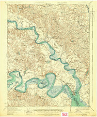
~ New Kent VA topo map, 1:62500 scale, 15 X 15 Minute, Historical, 1919, updated 1930
New Kent, Virginia, USGS topographic map dated 1919.
Includes geographic coordinates (latitude and longitude). This topographic map is suitable for hiking, camping, and exploring, or framing it as a wall map.
Printed on-demand using high resolution imagery, on heavy weight and acid free paper, or alternatively on a variety of synthetic materials.
Topos available on paper, Waterproof, Poly, or Tyvek. Usually shipping rolled, unless combined with other folded maps in one order.
- Product Number: USGS-5303216
- Free digital map download (high-resolution, GeoPDF): New Kent, Virginia (file size: 8 MB)
- Map Size: please refer to the dimensions of the GeoPDF map above
- Weight (paper map): ca. 55 grams
- Map Type: POD USGS Topographic Map
- Map Series: HTMC
- Map Verison: Historical
- Cell ID: 58369
- Scan ID: 188415
- Imprint Year: 1930
- Survey Year: 1918
- Datum: NAD
- Map Projection: Polyconic
- Map published by United States Army Corps of Engineers
- Map published by United States Department of War
- Map Language: English
- Scanner Resolution: 600 dpi
- Map Cell Name: New Kent
- Grid size: 15 X 15 Minute
- Date on map: 1919
- Map Scale: 1:62500
- Geographical region: Virginia, United States
Neighboring Maps:
All neighboring USGS topo maps are available for sale online at a variety of scales.
Spatial coverage:
Topo map New Kent, Virginia, covers the geographical area associated the following places:
- West Point - Courthouse Landing - Plum Point - Hillsboro - White Oak Landing - Brookeshire - Scotland Landing - Johnson Landing - Little Plymouth - Rickahock - Port Richmond - Elsom - Romancoke - Lanesville - Stevensville - Cumnberland (historical) - Allen Shop Corner - Wakema - Horse Landing - Mantapike - Dragonville - Cumnor - Mattaponi - White Oak Landing - Cinquoteck (historical) - King and Queen Court House - New Kent - Riverview Landing - Dahlgrens Corner - Carlton Corner - Shanghai - Truhart - Boardley - Cumberland Landing - Log Landing - Gordon Landing - Eltham - Cohoke - Matchot (historical)
- Map Area ID: AREA37.7537.5-77-76.75
- Northwest corner Lat/Long code: USGSNW37.75-77
- Northeast corner Lat/Long code: USGSNE37.75-76.75
- Southwest corner Lat/Long code: USGSSW37.5-77
- Southeast corner Lat/Long code: USGSSE37.5-76.75
- Northern map edge Latitude: 37.75
- Southern map edge Latitude: 37.5
- Western map edge Longitude: -77
- Eastern map edge Longitude: -76.75


