
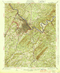
~ Lynchburg VA topo map, 1:62500 scale, 15 X 15 Minute, Historical, 1944
Lynchburg, Virginia, USGS topographic map dated 1944.
Includes geographic coordinates (latitude and longitude). This topographic map is suitable for hiking, camping, and exploring, or framing it as a wall map.
Printed on-demand using high resolution imagery, on heavy weight and acid free paper, or alternatively on a variety of synthetic materials.
Topos available on paper, Waterproof, Poly, or Tyvek. Usually shipping rolled, unless combined with other folded maps in one order.
- Product Number: USGS-5303044
- Free digital map download (high-resolution, GeoPDF): Lynchburg, Virginia (file size: 10 MB)
- Map Size: please refer to the dimensions of the GeoPDF map above
- Weight (paper map): ca. 55 grams
- Map Type: POD USGS Topographic Map
- Map Series: HTMC
- Map Verison: Historical
- Cell ID: 56997
- Scan ID: 188285
- Woodland Tint: Yes
- Survey Year: 1939
- Datum: NAD27
- Map Projection: Polyconic
- Map published by United States Geological Survey
- Map Language: English
- Scanner Resolution: 600 dpi
- Map Cell Name: Lynchburg
- Grid size: 15 X 15 Minute
- Date on map: 1944
- Map Scale: 1:62500
- Geographical region: Virginia, United States
Neighboring Maps:
All neighboring USGS topo maps are available for sale online at a variety of scales.
Spatial coverage:
Topo map Lynchburg, Virginia, covers the geographical area associated the following places:
- Ruritan - College Hill - Sherwood Forest - Blue Ridge Farms - Rustburg - Clay - Kelly - Belmont Acres - Meadowview Hills - Brookville - Williamsburg Manor - Forest Dale - Colony - Whetstone Hills - Reusens - Lanes Well Fork - Vista Acres - Sunny Banks - Old Stage Run - Deer Creek - Dearington - Bluemont Estates - Winesap - Glenwood - Melwood Manor - Forest Brook Hills - Mayfield - Three Fountains - Long Meadows - Edgewood - Jackson Heights - Great Oaks - Southland Acres - Lawyers - Sandusky Park - Hillsman Corner - Mount Athos (historical) - Yellow Branch - Black Rock Farm - West Lynchburg - Martins Store - Rivermont - Brush Tavern - Russellwood - White Rock Hill - Lynchburg - Joshua Falls - Woodlawn - Diamond Hill - Madison Heights - Galts Mill - Brightwell Mill - Perkins Park - Sheffield - Richland Hills - Kenwood Hills - Wright Shop - Daniels Hill - Doral Acres - Garland Hill - Woodbine Village - Sandy Bottom - Court House Hill - Federal Hill - Martins Shop - City Gomingo - Beechwood Hills - Keystone Forest - Seminole Ridge - Locust Gardens Mobile Home Park - Viking Fiord - Thomas Terrace - Deacon (historical) - Fairview Heights - Peakland - City Farm - Westview - Brandywine - Holiday Acres - Vista Acres - Long Mountain Estates - Powhatan - West Bethel - West Briar - Panorama Hills - Oak Grove - Maple Hill - Forest Hill - College Park - Ivanhoe Forest - Woodbine Acres - Lo Roy Acres - Lavino Village - Windsor Hills - East Brook - Magruder Hills - Westbrook - Tulip Tree Acres - Lakeview - Six Mile
- Map Area ID: AREA37.537.25-79.25-79
- Northwest corner Lat/Long code: USGSNW37.5-79.25
- Northeast corner Lat/Long code: USGSNE37.5-79
- Southwest corner Lat/Long code: USGSSW37.25-79.25
- Southeast corner Lat/Long code: USGSSE37.25-79
- Northern map edge Latitude: 37.5
- Southern map edge Latitude: 37.25
- Western map edge Longitude: -79.25
- Eastern map edge Longitude: -79


