
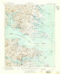
~ Kilmarnock VA topo map, 1:62500 scale, 15 X 15 Minute, Historical, 1916, updated 1956
Kilmarnock, Virginia, USGS topographic map dated 1916.
Includes geographic coordinates (latitude and longitude). This topographic map is suitable for hiking, camping, and exploring, or framing it as a wall map.
Printed on-demand using high resolution imagery, on heavy weight and acid free paper, or alternatively on a variety of synthetic materials.
Topos available on paper, Waterproof, Poly, or Tyvek. Usually shipping rolled, unless combined with other folded maps in one order.
- Product Number: USGS-5302986
- Free digital map download (high-resolution, GeoPDF): Kilmarnock, Virginia (file size: 6 MB)
- Map Size: please refer to the dimensions of the GeoPDF map above
- Weight (paper map): ca. 55 grams
- Map Type: POD USGS Topographic Map
- Map Series: HTMC
- Map Verison: Historical
- Cell ID: 56185
- Scan ID: 188234
- Imprint Year: 1956
- Survey Year: 1916
- Datum: NAD27
- Map Projection: Polyconic
- Map published by United States Army Corps of Engineers
- Map Language: English
- Scanner Resolution: 600 dpi
- Map Cell Name: Kilmarnock
- Grid size: 15 X 15 Minute
- Date on map: 1916
- Map Scale: 1:62500
- Geographical region: Virginia, United States
Neighboring Maps:
All neighboring USGS topo maps are available for sale online at a variety of scales.
Spatial coverage:
Topo map Kilmarnock, Virginia, covers the geographical area associated the following places:
- Good Luck - Regent - Wilton - Locklies - Merry Point - Cheaden (historical) - Queenstown - Nohead Bottom - Syringa - Deltaville - Topping - Hardyville - Millenbeck - Grace Point - Gwynn - Weems - Westland - Piankatank Shores - Harmony Village - North Weems - Free Shade Corner - Barretts - Byrdton - Ruark - Pitmans Corner - Palmer - Lynhams - Cove Colony - Wharton Grove (historical) - Dunton (historical) - White Stone - Grimstead - Hardings - Grafton - Ocran - Taft - Harveys - Ditchley - Grinels - Iberis - Kilmarnock - Highland Landing - Foxwells - Hartfield - Stingray Point - Woodstock - Sandy Bottom (historical) - Christ Church - Irvington - Wake - West Irvington - Amburg - Fairfield Landing - Cobbs Creek - Stampers - Dixie - Slabtown - Bushy
- Map Area ID: AREA37.7537.5-76.5-76.25
- Northwest corner Lat/Long code: USGSNW37.75-76.5
- Northeast corner Lat/Long code: USGSNE37.75-76.25
- Southwest corner Lat/Long code: USGSSW37.5-76.5
- Southeast corner Lat/Long code: USGSSE37.5-76.25
- Northern map edge Latitude: 37.75
- Southern map edge Latitude: 37.5
- Western map edge Longitude: -76.5
- Eastern map edge Longitude: -76.25


