
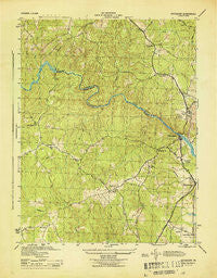
~ Occoquan VA topo map, 1:31680 scale, 7.5 X 7.5 Minute, Historical, 1944
Occoquan, Virginia, USGS topographic map dated 1944.
Includes geographic coordinates (latitude and longitude). This topographic map is suitable for hiking, camping, and exploring, or framing it as a wall map.
Printed on-demand using high resolution imagery, on heavy weight and acid free paper, or alternatively on a variety of synthetic materials.
Topos available on paper, Waterproof, Poly, or Tyvek. Usually shipping rolled, unless combined with other folded maps in one order.
- Product Number: USGS-5302362
- Free digital map download (high-resolution, GeoPDF): Occoquan, Virginia (file size: 7 MB)
- Map Size: please refer to the dimensions of the GeoPDF map above
- Weight (paper map): ca. 55 grams
- Map Type: POD USGS Topographic Map
- Map Series: HTMC
- Map Verison: Historical
- Cell ID: 32861
- Scan ID: 187511
- Woodland Tint: Yes
- Aerial Photo Year: 1943
- Datum: NAD27
- Map Projection: Polyconic
- Map published by United States Army Corps of Engineers
- Map published by United States Department of War
- Map Language: English
- Scanner Resolution: 600 dpi
- Map Cell Name: Occoquan
- Grid size: 7.5 X 7.5 Minute
- Date on map: 1944
- Map Scale: 1:31680
- Geographical region: Virginia, United States
Neighboring Maps:
All neighboring USGS topo maps are available for sale online at a variety of scales.
Spatial coverage:
Topo map Occoquan, Virginia, covers the geographical area associated the following places:
- Minnieville - Featherstone - Hoadly - Birchdale - Evansdale - Hillendale - Lakewood Estates - The Heights - Elm Farm Mobile Home Park - Featherstone Mobile Home Park - Lindendale - Mapledale - Marumsco Village - Neabsco Hills - Dale City - Darbydale - Marumsco Hills - Lorfax Heights - Farrs Corner - Potomac Mills - Minnieville Estates - Colony Woods - Forestdale - Laurel Hills - Lake Ridge - Gleatons Mobile Home Park - Holly Acres Mobile Home Park - Barksdale - Kerrydale - Bethel - Occoquan - Glendale - Bel Air Mobile Home Park - Marumsco Acres - Agnewville
- Map Area ID: AREA38.7538.625-77.375-77.25
- Northwest corner Lat/Long code: USGSNW38.75-77.375
- Northeast corner Lat/Long code: USGSNE38.75-77.25
- Southwest corner Lat/Long code: USGSSW38.625-77.375
- Southeast corner Lat/Long code: USGSSE38.625-77.25
- Northern map edge Latitude: 38.75
- Southern map edge Latitude: 38.625
- Western map edge Longitude: -77.375
- Eastern map edge Longitude: -77.25


