
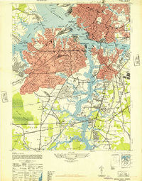
~ Norfolk South VA topo map, 1:24000 scale, 7.5 X 7.5 Minute, Historical, 1948
Norfolk South, Virginia, USGS topographic map dated 1948.
Includes geographic coordinates (latitude and longitude). This topographic map is suitable for hiking, camping, and exploring, or framing it as a wall map.
Printed on-demand using high resolution imagery, on heavy weight and acid free paper, or alternatively on a variety of synthetic materials.
Topos available on paper, Waterproof, Poly, or Tyvek. Usually shipping rolled, unless combined with other folded maps in one order.
- Product Number: USGS-5300056
- Free digital map download (high-resolution, GeoPDF): Norfolk South, Virginia (file size: 14 MB)
- Map Size: please refer to the dimensions of the GeoPDF map above
- Weight (paper map): ca. 55 grams
- Map Type: POD USGS Topographic Map
- Map Series: HTMC
- Map Verison: Historical
- Cell ID: 32262
- Scan ID: 186123
- Woodland Tint: Yes
- Aerial Photo Year: 1942
- Survey Year: 1944
- Datum: NAD27
- Map Projection: Transverse Mercator
- Map published by United States Army
- Map Language: English
- Scanner Resolution: 600 dpi
- Map Cell Name: Norfolk South
- Grid size: 7.5 X 7.5 Minute
- Date on map: 1948
- Map Scale: 1:24000
- Geographical region: Virginia, United States
Neighboring Maps:
All neighboring USGS topo maps are available for sale online at a variety of scales.
Spatial coverage:
Topo map Norfolk South, Virginia, covers the geographical area associated the following places:
- Alexander Corner - Grove Park - Williams Court - Park Place - Swanson Homes - Academy Park - Midway Mobile Home Park - Victory Park - Pinehurst - Doziers Corner - Saint Helena - Woodshire Mobile Home Park - Portsmouth - Cloverdale - Geneva Mobile Home Park - Norfolk - Berkley - Carolina Junction - South Hill - Westhaven - Chesapeake Mobile Home Park - Portlock - Chesterfield - R and H Mobile Court - Geneva Shores - West Munden - Gilmerton - McMilan Mobile Home Park - West Ghent - Brambleton - Yadkin - Dale Homes - Brentwood - Newton Park - Westhaven Park - Loxley Gardens - Sturbridge Village Mobile Home Park - Westover - Riverdale - Stoney's Mobile Home Park - Norcum Park - Buell - Oregon Acres - Waterview - Crestwood - Barnes Trailer Park - Woodland Terrace - Homecrest Mobile Home Park - Geneva Park - Huntersville - Cradock - Ghent - Plymouth Park - Providence Junction - Parkview - Norport Homes - Shea Terrace - West Norfolk - River Park - Alantic City - Campostella - Highland-Biltmore - Campostella Heights - Chesapeake - Avalon - Greenbriar - Edmonds Corner - Newtown - Edmonds Corner Mobile Home Park - Oregon Gardens - Port Norfolk - Loxley Place - Prentiss Park - Kingman - Admiralty Mobile Home Court - Portsmouth Heights - Cavalier Manor - Ballentine Place - Raleigh Heights - Trailer Acres Mobile Home Park - Douglas Park - Broadmoor - Gosport
- Map Area ID: AREA36.87536.75-76.375-76.25
- Northwest corner Lat/Long code: USGSNW36.875-76.375
- Northeast corner Lat/Long code: USGSNE36.875-76.25
- Southwest corner Lat/Long code: USGSSW36.75-76.375
- Southeast corner Lat/Long code: USGSSE36.75-76.25
- Northern map edge Latitude: 36.875
- Southern map edge Latitude: 36.75
- Western map edge Longitude: -76.375
- Eastern map edge Longitude: -76.25


