
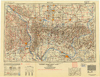
~ Paducah KY topo map, 1:250000 scale, 1 X 2 Degree, Historical, 1949
Paducah, Kentucky, USGS topographic map dated 1949.
Includes geographic coordinates (latitude and longitude). This topographic map is suitable for hiking, camping, and exploring, or framing it as a wall map.
Printed on-demand using high resolution imagery, on heavy weight and acid free paper, or alternatively on a variety of synthetic materials.
Topos available on paper, Waterproof, Poly, or Tyvek. Usually shipping rolled, unless combined with other folded maps in one order.
- Product Number: USGS-5295026
- Free digital map download (high-resolution, GeoPDF): Paducah, Kentucky (file size: 13 MB)
- Map Size: please refer to the dimensions of the GeoPDF map above
- Weight (paper map): ca. 55 grams
- Map Type: POD USGS Topographic Map
- Map Series: HTMC
- Map Verison: Historical
- Cell ID: 68951
- Scan ID: 803860
- Aerial Photo Year: 1942
- Datum: NAD27
- Map Projection: Transverse Mercator
- Map published by United States Geological Survey
- Map published by United States Army Corps of Engineers
- Map published by United States Army
- Map Language: English
- Scanner Resolution: 508 dpi
- Map Cell Name: Paducah
- Grid size: 1 X 2 Degree
- Date on map: 1949
- Map Scale: 1:250000
- Geographical region: Kentucky, United States
Neighboring Maps:
All neighboring USGS topo maps are available for sale online at a variety of scales.
Spatial coverage:
Topo map Paducah, Kentucky, covers the geographical area associated the following places:
- New Hamburg - Reynolds Ford - Karbers Ridge - Blodgett - Hodges Park - Crowell Landing - Biehle - Ceredo - Frances - Future City - Reeds Station - Flatwoods - New Liberty - Greenville (historical) - Huskey - Marion Mobile Home Village - Pocahontas - Cooper Landing - Julien Hill - Cora - Burfordville - Mulfordtown - Shakerag - Pershing - Hartle Ford - Lake City - Locust Grove (historical) - Irma - Neelys Landing - Altona - Gowansville (historical) - Glendale (historical) - Mitchellsville - Bender (historical) - Eddyville - Rock Creek - Reyburn (historical) - Eldorado - Old Brownfield - Spring Grove - Rectorville (historical) - Sandusky - Spring Hill - Junction - Leanderville - De Soto - Hamletsburg - Lee (historical) - Texas Junction - Shawneetown - New Burnside - Dawleys - Kenton (historical) - Gilbertsville - Waltersburg - Delta - White Ash - Mount Carbon - Stanley Landing - Cedar Hills - Rockview - Bayou - Gordonville - Peters Creek - Somerset - Little Cypress - Jonesboro - Eagle - Grand Tower - Millheim - Maxon - Balcom - Claryville - Indian Hills - Highland Church (historical) - Stone (historical) - Mitchell Landing - Willisville - Grimsby - Midway - Horseshoe - Mullikin Junction - Temple Hill - Shetlerville - New Dennison - Blairsville - America - Boskydell - Kuttawa - West City - Crenshaw Crossing - Millersville - Woodville - Bremen - Bowlesville (historical) - Morley - Bleda - Hodgeville - Marion - Mountain Glen
- Map Area ID: AREA3837-90-88
- Northwest corner Lat/Long code: USGSNW38-90
- Northeast corner Lat/Long code: USGSNE38-88
- Southwest corner Lat/Long code: USGSSW37-90
- Southeast corner Lat/Long code: USGSSE37-88
- Northern map edge Latitude: 38
- Southern map edge Latitude: 37
- Western map edge Longitude: -90
- Eastern map edge Longitude: -88


