
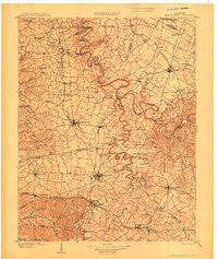
~ Harrodsburg KY topo map, 1:125000 scale, 30 X 30 Minute, Historical, 1905
Harrodsburg, Kentucky, USGS topographic map dated 1905.
Includes geographic coordinates (latitude and longitude). This topographic map is suitable for hiking, camping, and exploring, or framing it as a wall map.
Printed on-demand using high resolution imagery, on heavy weight and acid free paper, or alternatively on a variety of synthetic materials.
Topos available on paper, Waterproof, Poly, or Tyvek. Usually shipping rolled, unless combined with other folded maps in one order.
- Product Number: USGS-5294900
- Free digital map download (high-resolution, GeoPDF): Harrodsburg, Kentucky (file size: 7 MB)
- Map Size: please refer to the dimensions of the GeoPDF map above
- Weight (paper map): ca. 55 grams
- Map Type: POD USGS Topographic Map
- Map Series: HTMC
- Map Verison: Historical
- Cell ID: 65651
- Scan ID: 708838
- Survey Year: 1903
- Datum: Unstated
- Map Projection: Unstated
- Map published by United States Geological Survey
- Map Language: English
- Scanner Resolution: 508 dpi
- Map Cell Name: Harrodsburg
- Grid size: 30 X 30 Minute
- Date on map: 1905
- Map Scale: 1:125000
- Geographical region: Kentucky, United States
Neighboring Maps:
All neighboring USGS topo maps are available for sale online at a variety of scales.
Spatial coverage:
Topo map Harrodsburg, Kentucky, covers the geographical area associated the following places:
- Stone - Atoka - Edgewood (historical) - Mount Lebanon - Lancaster - Dixville - Pink - West Danville - Bruners Chapel (historical) - Cummins Ferry (historical) - Fitchport (historical) - McCormack (historical) - Harmony (historical) - West Lynn (historical) - Kirkwood - Little Hickman - Chattersville (historical) - Buena Vista - Green Acres - Stanford - Judson - Dixon Town - Davistown - Lynnwood (historical) - High Bridge - Butchertown - Battle (historical) - South Elkhorn - Bushtown - Hedgeville - Three Forks - Clifton - Hyattsville - Oregon - Jessamine - Danville - Burgin - Hickory Grove (historical) - Marcellus - Forkland - Guy (historical) - Monticello - Laurel Hill (historical) - McBrayer - Cane Hurst (historical) - Hall - Alum Springs - Duncan - Crisman Mill (historical) - Mount Hebron (historical) - Vanarsdell - Bourne - Brumfield - Fishers Station (historical) - Ballard - Wilsonville - Salvisa - Lexington Park (historical) - Harrods Station (historical) - Talmage - Lucto (historical) - Nicholasville - Hickory Grove - Oakdale (historical) - Oakland (historical) - McCreary - Liberty (historical) - Logantown - Daugherty Station (historical) - Lucton (historical) - Toddville - Milledgeville - Mayo - Little Needmore - Nealton - Houchin (historical) - Nonesuch - Mortonsville - Nevin - Morgan Manor Addition - Wilson Station (historical) - Faulconer - McAfee - Brannon - Oak Hill (historical) - Lansdowne - Union Mills - Edgewood (historical) - Shawnee Run (historical) - Davis Hill - Bushtown - Stringtown - Braxton - Keene - Vineyard - Riverview Estates - Wilmore Park (historical) - Pekin (historical) - Camp Nelson (historical) - Junction City
- Map Area ID: AREA3837.5-85-84.5
- Northwest corner Lat/Long code: USGSNW38-85
- Northeast corner Lat/Long code: USGSNE38-84.5
- Southwest corner Lat/Long code: USGSSW37.5-85
- Southeast corner Lat/Long code: USGSSE37.5-84.5
- Northern map edge Latitude: 38
- Southern map edge Latitude: 37.5
- Western map edge Longitude: -85
- Eastern map edge Longitude: -84.5


