
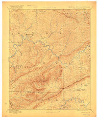
~ Cumberland Gap KY topo map, 1:125000 scale, 30 X 30 Minute, Historical, 1891, updated 1917
Cumberland Gap, Kentucky, USGS topographic map dated 1891.
Includes geographic coordinates (latitude and longitude). This topographic map is suitable for hiking, camping, and exploring, or framing it as a wall map.
Printed on-demand using high resolution imagery, on heavy weight and acid free paper, or alternatively on a variety of synthetic materials.
Topos available on paper, Waterproof, Poly, or Tyvek. Usually shipping rolled, unless combined with other folded maps in one order.
- Product Number: USGS-5294876
- Free digital map download (high-resolution, GeoPDF): Cumberland Gap, Kentucky (file size: 7 MB)
- Map Size: please refer to the dimensions of the GeoPDF map above
- Weight (paper map): ca. 55 grams
- Map Type: POD USGS Topographic Map
- Map Series: HTMC
- Map Verison: Historical
- Cell ID: 65301
- Scan ID: 708485
- Imprint Year: 1917
- Survey Year: 1886
- Datum: Unstated
- Map Projection: Unstated
- Map published by United States Geological Survey
- Map Language: English
- Scanner Resolution: 508 dpi
- Map Cell Name: Cumberland Gap
- Grid size: 30 X 30 Minute
- Date on map: 1891
- Map Scale: 1:125000
- Geographical region: Kentucky, United States
Neighboring Maps:
All neighboring USGS topo maps are available for sale online at a variety of scales.
Spatial coverage:
Topo map Cumberland Gap, Kentucky, covers the geographical area associated the following places:
- Laurel Ford - Manring - Glendon Coal Camp (historical) - Pearl - Harrogate - Swanpond - Jenson - Bimble - Straight Creek - Gausdale - Wheeler - Beverly - Hamblim - Arjay - Reliance - Ferndale - Girdler - Frakes - Rain - Nash Mill - Binghamtown - Patterson Crossroads - Olcott - Cannon - Hutch - Colmar - Rossland - Blanche - Hinkle - Wheeler - Stoney Fork - Cardinal - Turkey Creek (historical) - Miracle - Erose - Fourmile - Emanuel - Cave Spring - Balkan - Kettle Island Coal Camp (historical) - Hamlin Town - Anthras - Eagan - Swan Lake - Cary - Meldrum - Yellow Creek - Middlesboro - Oaks - Gibson Mill - Pineville - Stony Fork Junction - Himyar - Barbourville - Bryson Mountain - Crane Nest - Davisburg - Pruden - Tejay - Jaybel - Flat Lick - Motch - Varilla - Kettle Island - Baughman - Nugym (historical) - Black Snake - Capito - Lower Cumberland (historical) - Marion - Combs - Henderson Grove - Mockingbird Mobile Home Park - Apple Grove (historical) - Dewitt - Tiprell - Minton Mill - Riverside - Rella - Cubage - Davis Bend (historical) - Harbell - Forge Ridge - Pruden - Valley Creek - Red Hill - Poplar Grove - Siler - Little Creek - Clear Creek Springs - Avis (historical) - Pump Springs Mobile Home Park - Carpenter - Kidwell - Brush Creek (historical) - Davis Station (historical) - Powell Valley - Rim Camp (historical) - Trosper - Cumberland Gap
- Map Area ID: AREA3736.5-84-83.5
- Northwest corner Lat/Long code: USGSNW37-84
- Northeast corner Lat/Long code: USGSNE37-83.5
- Southwest corner Lat/Long code: USGSSW36.5-84
- Southeast corner Lat/Long code: USGSSE36.5-83.5
- Northern map edge Latitude: 37
- Southern map edge Latitude: 36.5
- Western map edge Longitude: -84
- Eastern map edge Longitude: -83.5


