
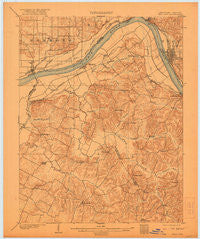
~ Tell City IN topo map, 1:62500 scale, 15 X 15 Minute, Historical, 1903, updated 1921
Tell City, Indiana, USGS topographic map dated 1903.
Includes geographic coordinates (latitude and longitude). This topographic map is suitable for hiking, camping, and exploring, or framing it as a wall map.
Printed on-demand using high resolution imagery, on heavy weight and acid free paper, or alternatively on a variety of synthetic materials.
Topos available on paper, Waterproof, Poly, or Tyvek. Usually shipping rolled, unless combined with other folded maps in one order.
- Product Number: USGS-5294740
- Free digital map download (high-resolution, GeoPDF): Tell City, Indiana (file size: 5 MB)
- Map Size: please refer to the dimensions of the GeoPDF map above
- Weight (paper map): ca. 55 grams
- Map Type: POD USGS Topographic Map
- Map Series: HTMC
- Map Verison: Historical
- Cell ID: 63414
- Scan ID: 804320
- Imprint Year: 1921
- Survey Year: 1900
- Datum: Unstated
- Map Projection: Unstated
- Map published by United States Geological Survey
- Map Language: English
- Scanner Resolution: 508 dpi
- Map Cell Name: Tell City
- Grid size: 15 X 15 Minute
- Date on map: 1903
- Map Scale: 1:62500
- Geographical region: Indiana, United States
Neighboring Maps:
All neighboring USGS topo maps are available for sale online at a variety of scales.
Spatial coverage:
Topo map Tell City, Indiana, covers the geographical area associated the following places:
- Fenn Haven - Knottsville - Tywhapity Bottoms (historical) - Lewisport - Haywood Chapel (historical) - Spice Knob - Chambers - Scythia - Cullen (historical) - Yelvington - Mount Zion (historical) - Pellville - Ensor - Waitman - Saint Lawrence (historical) - Grandview - Floral - Chestnut Grove (historical) - Maceo - Weberstown - Adair - Tell City - Petri - Hawesville - Goering - Gatewood - Bethlehem (historical) - Troy
- Map Area ID: AREA3837.75-87-86.75
- Northwest corner Lat/Long code: USGSNW38-87
- Northeast corner Lat/Long code: USGSNE38-86.75
- Southwest corner Lat/Long code: USGSSW37.75-87
- Southeast corner Lat/Long code: USGSSE37.75-86.75
- Northern map edge Latitude: 38
- Southern map edge Latitude: 37.75
- Western map edge Longitude: -87
- Eastern map edge Longitude: -86.75


