
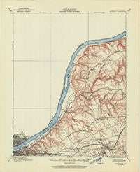
~ Prospect KY topo map, 1:62500 scale, 15 X 15 Minute, Historical, 1905, updated 1962
Prospect, Kentucky, USGS topographic map dated 1905.
Includes geographic coordinates (latitude and longitude). This topographic map is suitable for hiking, camping, and exploring, or framing it as a wall map.
Printed on-demand using high resolution imagery, on heavy weight and acid free paper, or alternatively on a variety of synthetic materials.
Topos available on paper, Waterproof, Poly, or Tyvek. Usually shipping rolled, unless combined with other folded maps in one order.
- Product Number: USGS-5294668
- Free digital map download (high-resolution, GeoPDF): Prospect, Kentucky (file size: 4 MB)
- Map Size: please refer to the dimensions of the GeoPDF map above
- Weight (paper map): ca. 55 grams
- Map Type: POD USGS Topographic Map
- Map Series: HTMC
- Map Verison: Historical
- Cell ID: 61333
- Scan ID: 803913
- Imprint Year: 1962
- Survey Year: 1905
- Datum: NAD27
- Map Projection: Polyconic
- Map published by United States Geological Survey
- Map Language: English
- Scanner Resolution: 508 dpi
- Map Cell Name: Prospect
- Grid size: 15 X 15 Minute
- Date on map: 1905
- Map Scale: 1:62500
- Geographical region: Kentucky, United States
Neighboring Maps:
All neighboring USGS topo maps are available for sale online at a variety of scales.
Spatial coverage:
Topo map Prospect, Kentucky, covers the geographical area associated the following places:
- Creekside - Berrytown - Rolling Fields - O'Bannon - Utica - Whipps Millgate - Mockingbird Valley - Goshen - Druid Hills - Longview Beach - Glenview - Glenview Manor - Lake Louisvilla - Watson - Norwood - Woodside - Seminary Village - Langdon Place - Richlawn - Ballardsville - Warwick Villa - Lyndon - Riverwood - Brownsboro Village - Gulthrie Beach - Ten Broeck - Riverside Beach - Woodlawn Park - Keeneland - Clark Siding - Longview - Barbourmeade - Skylight - Oldham Acres - Goose Creek - Coldstream - Indian Hills - Beechwood Village - Windy Hills - Freys Hill - Transylvania Beach - Murray Hill - Meadowbrook Farm - Juniper Beach - Plantation - Green Spring - Spring Valley - Manor Creek - Maryhill Estates - Brownsboro Farm - Runyantown - Glenview Heights - Owen - Indian Hills Cherokee Section - Worthington - Sylvan Grove - Meadow Vale - Sunset Village - Germany - Rolling Hills - Harmony Village - Winding Falls - Anchorage - Robinswood - Belknap Beach - Fincastle - Jeffersonville - Hickory Hill - Rolling Hills - Beechland Beach - Liberty (historical) - Glenview Acres - Hillcrest - Old Brownsboro Place - Arctic Springs - Cherrywood Village - Bellewood - Oak Park - Broeck Pointe - Hills and Dales - Springville - Saint Matthews - Griffytown - Harmony Lake Estates - Springdale - Crossgate - Glenview Hills - River Bluff - Prospect - Moorland - Thornhill - Charlestown - Vesta - Prather - Bellemeade - Worthington Hills - Briarwood - Lakeland - Fraziertown - Graymoor-Devondale
- Map Area ID: AREA38.538.25-85.75-85.5
- Northwest corner Lat/Long code: USGSNW38.5-85.75
- Northeast corner Lat/Long code: USGSNE38.5-85.5
- Southwest corner Lat/Long code: USGSSW38.25-85.75
- Southeast corner Lat/Long code: USGSSE38.25-85.5
- Northern map edge Latitude: 38.5
- Southern map edge Latitude: 38.25
- Western map edge Longitude: -85.75
- Eastern map edge Longitude: -85.5


