
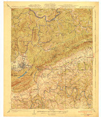
~ Middlesboro KY topo map, 1:62500 scale, 15 X 15 Minute, Historical, 1930
Middlesboro, Kentucky, USGS topographic map dated 1930.
Includes geographic coordinates (latitude and longitude). This topographic map is suitable for hiking, camping, and exploring, or framing it as a wall map.
Printed on-demand using high resolution imagery, on heavy weight and acid free paper, or alternatively on a variety of synthetic materials.
Topos available on paper, Waterproof, Poly, or Tyvek. Usually shipping rolled, unless combined with other folded maps in one order.
- Product Number: USGS-5294560
- Free digital map download (high-resolution, GeoPDF): Middlesboro, Kentucky (file size: 8 MB)
- Map Size: please refer to the dimensions of the GeoPDF map above
- Weight (paper map): ca. 55 grams
- Map Type: POD USGS Topographic Map
- Map Series: HTMC
- Map Verison: Historical
- Cell ID: 57594
- Scan ID: 709279
- Woodland Tint: Yes
- Survey Year: 1927
- Datum: NAD
- Map Projection: Polyconic
- Map published by United States Geological Survey
- Map Language: English
- Scanner Resolution: 508 dpi
- Map Cell Name: Middlesboro
- Grid size: 15 X 15 Minute
- Date on map: 1930
- Map Scale: 1:62500
- Geographical region: Kentucky, United States
Neighboring Maps:
All neighboring USGS topo maps are available for sale online at a variety of scales.
Spatial coverage:
Topo map Middlesboro, Kentucky, covers the geographical area associated the following places:
- Riverside - Cubage - Davis Station (historical) - River View - Meldrum - Varilla - Gibson Mill - Minton Mill - Nash Mill - Town Creek - Tiprell - Cave Spring - Little Creek - Wheeler - Red Hill - Combs - Middlesboro - Binghamtown - Clear Creek Springs - Patterson Crossroads - Harbell - Wasioto - Gibson Station - Pump Springs Mobile Home Park - Ponza - Bacchus - Vancel Mill - Harrogate - Hutch - Mockingbird Mobile Home Park - Shawanee - Calvin - East Pineville - Ferndale - Forge Ridge - Oaks - Arthur - Cumberland Gap - Poplar Grove - Colmar
- Map Area ID: AREA36.7536.5-83.75-83.5
- Northwest corner Lat/Long code: USGSNW36.75-83.75
- Northeast corner Lat/Long code: USGSNE36.75-83.5
- Southwest corner Lat/Long code: USGSSW36.5-83.75
- Southeast corner Lat/Long code: USGSSE36.5-83.5
- Northern map edge Latitude: 36.75
- Southern map edge Latitude: 36.5
- Western map edge Longitude: -83.75
- Eastern map edge Longitude: -83.5


