
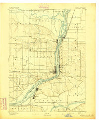
~ Leclaire IA topo map, 1:62500 scale, 15 X 15 Minute, Historical, 1893
Leclaire, Iowa, USGS topographic map dated 1893.
Includes geographic coordinates (latitude and longitude). This topographic map is suitable for hiking, camping, and exploring, or framing it as a wall map.
Printed on-demand using high resolution imagery, on heavy weight and acid free paper, or alternatively on a variety of synthetic materials.
Topos available on paper, Waterproof, Poly, or Tyvek. Usually shipping rolled, unless combined with other folded maps in one order.
- Product Number: USGS-5283429
- Free digital map download (high-resolution, GeoPDF): Leclaire, Iowa (file size: 5 MB)
- Map Size: please refer to the dimensions of the GeoPDF map above
- Weight (paper map): ca. 55 grams
- Map Type: POD USGS Topographic Map
- Map Series: HTMC
- Map Verison: Historical
- Cell ID: 56628
- Scan ID: 174990
- Survey Year: 1890
- Datum: Unstated
- Map Projection: Unstated
- Map published by United States Geological Survey
- Keywords: Nonstandard Press Run
- Map Language: English
- Scanner Resolution: 600 dpi
- Map Cell Name: Leclaire
- Grid size: 15 X 15 Minute
- Date on map: 1893
- Map Scale: 1:62500
- Geographical region: Iowa, United States
Neighboring Maps:
All neighboring USGS topo maps are available for sale online at a variety of scales.
Spatial coverage:
Topo map Leclaire, Iowa, covers the geographical area associated the following places:
- Barstow - Folletts - Cedar Brook - Great Oaks - Cleveland - Glendale Mobile Home Park - Carriage Place - Rustic Acres - Riverdale - Argo - Silvis - Rivercrest Estates - Princeton - Rapids City - Panorama Park - Cordova - Devils Glen Mobile Home Court - Pleasant Valley - Hampton - Port Byron - Babcock - Le Claire - Sherton Heights - Osborn - McCausland - East Moline
- Map Area ID: AREA41.7541.5-90.5-90.25
- Northwest corner Lat/Long code: USGSNW41.75-90.5
- Northeast corner Lat/Long code: USGSNE41.75-90.25
- Southwest corner Lat/Long code: USGSSW41.5-90.5
- Southeast corner Lat/Long code: USGSSE41.5-90.25
- Northern map edge Latitude: 41.75
- Southern map edge Latitude: 41.5
- Western map edge Longitude: -90.5
- Eastern map edge Longitude: -90.25


