
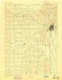
~ Iowa City IA topo map, 1:62500 scale, 15 X 15 Minute, Historical, 1891
Iowa City, Iowa, USGS topographic map dated 1891.
Includes geographic coordinates (latitude and longitude). This topographic map is suitable for hiking, camping, and exploring, or framing it as a wall map.
Printed on-demand using high resolution imagery, on heavy weight and acid free paper, or alternatively on a variety of synthetic materials.
Topos available on paper, Waterproof, Poly, or Tyvek. Usually shipping rolled, unless combined with other folded maps in one order.
- Product Number: USGS-5283401
- Free digital map download (high-resolution, GeoPDF): Iowa City, Iowa (file size: 5 MB)
- Map Size: please refer to the dimensions of the GeoPDF map above
- Weight (paper map): ca. 55 grams
- Map Type: POD USGS Topographic Map
- Map Series: HTMC
- Map Verison: Historical
- Cell ID: 55772
- Scan ID: 174877
- Survey Year: 1887
- Datum: Unstated
- Map Projection: Unstated
- Map published by United States Geological Survey
- Keywords: Nonstandard Press Run
- Map Language: English
- Scanner Resolution: 600 dpi
- Map Cell Name: Iowa City
- Grid size: 15 X 15 Minute
- Date on map: 1891
- Map Scale: 1:62500
- Geographical region: Iowa, United States
Neighboring Maps:
All neighboring USGS topo maps are available for sale online at a variety of scales.
Spatial coverage:
Topo map Iowa City, Iowa, covers the geographical area associated the following places:
- Frytown - Cosgrove - Forest View Trailer Court - Coral Trailer Park - Tiffin - Hilltop Mobile Home Park - Coralville - University Heights - Oakdale - Vernon - Sharon Center - Lake Ridge Mobile Home Park - Holiday Mobile Home Court - Baculis Mobile Home Park - Clear Creek Mobile Home Park - North Liberty - Western Hills Mobine Estates - Iowa City - Hills
- Map Area ID: AREA41.7541.5-91.75-91.5
- Northwest corner Lat/Long code: USGSNW41.75-91.75
- Northeast corner Lat/Long code: USGSNE41.75-91.5
- Southwest corner Lat/Long code: USGSSW41.5-91.75
- Southeast corner Lat/Long code: USGSSE41.5-91.5
- Northern map edge Latitude: 41.75
- Southern map edge Latitude: 41.5
- Western map edge Longitude: -91.75
- Eastern map edge Longitude: -91.5


