
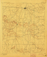
~ Abilene TX topo map, 1:125000 scale, 30 X 30 Minute, Historical, 1892, updated 1908
Abilene, Texas, USGS topographic map dated 1892.
Includes geographic coordinates (latitude and longitude). This topographic map is suitable for hiking, camping, and exploring, or framing it as a wall map.
Printed on-demand using high resolution imagery, on heavy weight and acid free paper, or alternatively on a variety of synthetic materials.
Topos available on paper, Waterproof, Poly, or Tyvek. Usually shipping rolled, unless combined with other folded maps in one order.
- Product Number: USGS-5480223
- Free digital map download (high-resolution, GeoPDF): Abilene, Texas (file size: 7 MB)
- Map Size: please refer to the dimensions of the GeoPDF map above
- Weight (paper map): ca. 55 grams
- Map Type: POD USGS Topographic Map
- Map Series: HTMC
- Map Verison: Historical
- Cell ID: 64843
- Scan ID: 123678
- Imprint Year: 1908
- Visual Version Number: 1
- Survey Year: 1890
- Datum: Unstated
- Map Projection: Unstated
- Map published by United States Geological Survey
- Map Language: English
- Scanner Resolution: 600 dpi
- Map Cell Name: Abilene
- Grid size: 30 X 30 Minute
- Date on map: 1892
- Map Scale: 1:125000
- Geographical region: Texas, United States
Neighboring Maps:
All neighboring USGS topo maps are available for sale online at a variety of scales.
Spatial coverage:
Topo map Abilene, Texas, covers the geographical area associated the following places:
- Caps - Abilene - Rogers - View - Elmdale - Drasco - Goldsboro - Potosi - Cozart - Buffalo Gap - Denton - Dudley - Bradshaw - Oplin - Guion - Mount Pleasant - Tye - Tuscola - Eula - Impact - Wylie - Lawn - Ovalo
- Map Area ID: AREA32.532-100-99.5
- Northwest corner Lat/Long code: USGSNW32.5-100
- Northeast corner Lat/Long code: USGSNE32.5-99.5
- Southwest corner Lat/Long code: USGSSW32-100
- Southeast corner Lat/Long code: USGSSE32-99.5
- Northern map edge Latitude: 32.5
- Southern map edge Latitude: 32
- Western map edge Longitude: -100
- Eastern map edge Longitude: -99.5


