
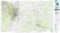
~ Austin TX topo map, 1:100000 scale, 30 X 60 Minute, Historical, 1985, updated 1992
Austin, Texas, USGS topographic map dated 1985.
Includes geographic coordinates (latitude and longitude). This topographic map is suitable for hiking, camping, and exploring, or framing it as a wall map.
Printed on-demand using high resolution imagery, on heavy weight and acid free paper, or alternatively on a variety of synthetic materials.
Topos available on paper, Waterproof, Poly, or Tyvek. Usually shipping rolled, unless combined with other folded maps in one order.
- Product Number: USGS-5479697
- Free digital map download (high-resolution, GeoPDF): Austin, Texas (file size: 29 MB)
- Map Size: please refer to the dimensions of the GeoPDF map above
- Weight (paper map): ca. 55 grams
- Map Type: POD USGS Topographic Map
- Map Series: HTMC
- Map Verison: Historical
- Cell ID: 67083
- Scan ID: 121859
- Imprint Year: 1992
- Woodland Tint: Yes
- Visual Version Number: 2
- Aerial Photo Year: 1981
- Edit Year: 1985
- Datum: NAD27
- Map Projection: Universal Transverse Mercator
- Map published by United States Geological Survey
- Map Language: English
- Scanner Resolution: 600 dpi
- Map Cell Name: Austin
- Grid size: 30 X 60 Minute
- Date on map: 1985
- Map Scale: 1:100000
- Geographical region: Texas, United States
Neighboring Maps:
All neighboring USGS topo maps are available for sale online at a variety of scales.
Spatial coverage:
Topo map Austin, Texas, covers the geographical area associated the following places:
- Sayersville - Pin Oak - Elysium - Alum Creek - Manda - Lytton Springs - Manor - Wyldwood - Coxville - Littig - Cele - Shiloh - Niederwald - Circle D Estates - Bee Cave - Rollingwood - Vinson - Bastrop - McDade - Dunlap - Jonestown - Buda - McNeil - Camp Swift - Pilot Knob - Turnersville - Creedmoor - Hudson Bend - Idyle Hour Acres - Walnut Forest - Kincheonville - Decker - Volente - Merrelltown - San Leanna - Point Venture - Hays City - Carl - Montopolis - Del Valle - Utley - Waters Park - Three Points - Greenshores - Elgin - Villa Siesta Retirement Village - Four Points - Barton Creek - Smithville - Austin - Pleasant Hill - Pflugerville - Upton - Cedar Valley - Shiloh (historical) - Butler - Lakeway - Structure - Pershing - Flatrock Ford - New Katy - River Hills - Lund - New Sweden - Elroy - Siloam - Pond Springs - Cedar Creek - Manchaca - Pine Hills - Clearview - Mendoza - KC Estates - Fedor - Edgewater Beach - Norman - Sunset Valley - West Lake Hills - Rices Crossing - The Hills - Dessau Fountains - Onion Creek - Knobbs Springs - Goforth - Marshall Ford - Williamson - Daffan - Iglehart - Windemere - Ward Spring - Hays - Swiftex - Type - Buffalo Gap - Webberville - Phelan - Tanglewood Forest - Mustang Ridge - North Shore Acres - Ford Oaks
- Map Area ID: AREA30.530-98-97
- Northwest corner Lat/Long code: USGSNW30.5-98
- Northeast corner Lat/Long code: USGSNE30.5-97
- Southwest corner Lat/Long code: USGSSW30-98
- Southeast corner Lat/Long code: USGSSE30-97
- Northern map edge Latitude: 30.5
- Southern map edge Latitude: 30
- Western map edge Longitude: -98
- Eastern map edge Longitude: -97


