
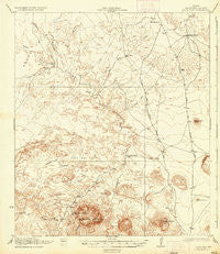
~ Agua Fria TX topo map, 1:62500 scale, 15 X 15 Minute, Historical, 1937
Agua Fria, Texas, USGS topographic map dated 1937.
Includes geographic coordinates (latitude and longitude). This topographic map is suitable for hiking, camping, and exploring, or framing it as a wall map.
Printed on-demand using high resolution imagery, on heavy weight and acid free paper, or alternatively on a variety of synthetic materials.
Topos available on paper, Waterproof, Poly, or Tyvek. Usually shipping rolled, unless combined with other folded maps in one order.
- Product Number: USGS-5477937
- Free digital map download (high-resolution, GeoPDF): Agua Fria, Texas (file size: 6 MB)
- Map Size: please refer to the dimensions of the GeoPDF map above
- Weight (paper map): ca. 55 grams
- Map Type: POD USGS Topographic Map
- Map Series: HTMC
- Map Verison: Historical
- Cell ID: 50365
- Scan ID: 105553
- Visual Version Number: 2
- Survey Year: 1917
- Datum: NAD
- Map Projection: Polyconic
- Map published by United States Army Corps of Engineers
- Map published by United States Department of War
- Map Language: English
- Scanner Resolution: 600 dpi
- Map Cell Name: Agua Fria
- Grid size: 15 X 15 Minute
- Date on map: 1937
- Map Scale: 1:62500
- Geographical region: Texas, United States
Neighboring Maps:
All neighboring USGS topo maps are available for sale online at a variety of scales.
Spatial coverage:
Topo map Agua Fria, Texas, covers the geographical area associated the following places:
- Red Bluff - Aqua Fria Mountain - Black Hill - Hammond Ranch Lake Dam - Alamo de Cesario Creek - Gray Hill - Agua Fria Trail - Packsaddle Mountain - Dewees Tank - White Trail - Hale Draw - Adams Ranch - Agua Fria Draw - Fizzle Flat - Hammond Ranch Lake - Camels Hump - Cheosa Waterhole - Musgrave Creek - Long Hills - Crystal Creek - Burnt House Camp - Agua Fria Springs - Aqua Fria Spring - Terlingua Trail - Hale Cabin - Old Stage Stand - Dog Canyon - Taurus Mesa Airport - Point Draw - Paint Mountain
- Map Area ID: AREA29.7529.5-103.75-103.5
- Northwest corner Lat/Long code: USGSNW29.75-103.75
- Northeast corner Lat/Long code: USGSNE29.75-103.5
- Southwest corner Lat/Long code: USGSSW29.5-103.75
- Southeast corner Lat/Long code: USGSSE29.5-103.5
- Northern map edge Latitude: 29.75
- Southern map edge Latitude: 29.5
- Western map edge Longitude: -103.75
- Eastern map edge Longitude: -103.5


