
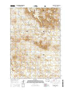
~ McKenzie Butte SD topo map, 1:24000 scale, 7.5 X 7.5 Minute, 2015
McKenzie Butte, South Dakota, USGS topographic map dated 2015.
Includes geographic coordinates (latitude and longitude). This topographic map is suitable for hiking, camping, and exploring, or framing it as a wall map.
Printed on-demand using high resolution imagery, on heavy weight and acid free paper, or alternatively on a variety of synthetic materials.
Topos available on paper, Waterproof, Poly, or Tyvek. Usually shipping rolled, unless combined with other folded maps in one order.
- Product Number: USGS-8011925
- Free digital map download (high-resolution, GeoPDF): McKenzie Butte, South Dakota (file size: 23 MB)
- Map Size: please refer to the dimensions of the GeoPDF map above
- Weight (paper map): ca. 55 grams
- Map Type: POD USGS Topographic Map
- Map Series: US Topo
- Map Verison: Current
- Cell ID: 28438
- Datum: North American Datum of 1983
- Map Projection: Transverse Mercator
- Map Cell Name: McKenzie Butte
- Grid size: 7.5 X 7.5 Minute
- Date on map: 2015
- Map Scale: 1:24000
- Geographical region: South Dakota, United States
Neighboring Maps:
All neighboring USGS topo maps are available for sale online at a variety of scales.
Spatial coverage:
Topo map McKenzie Butte, South Dakota, covers the geographical area associated the following places:
- Thumb Butte - Unorganized Territory of North Harding - Niemi Number 4 Dam - McKenzie Gulch - Cave Hills Lutheran Cemetery - Niemi Number 3 Dam - South Cave Hills - Van Offern Butte - Niemi Number 1 Dam - Juhala Hill - Sheep Mountain - John Brown Spring Number Two - Cottonwood Creek - John Brown Spring Number One - Cave Hills Cattle Company Ranch - Niemi Number 2 Dam - Hilton Mine - McKenzie Spring - W O Johnson Ranch - Casper Gulch Spring - Township of Hilton - McKenzie Butte - Holdup Canyon - Boot Creek - Johnson Spring - Penttila Butte - Casper Gulch - M Butler Ranch - Argyle Dam - Cave Hills Church - Red Butte - Niemi Number 5 Dam - Alcorn Dam
- Map Area ID: AREA45.7545.625-103.625-103.5
- Northwest corner Lat/Long code: USGSNW45.75-103.625
- Northeast corner Lat/Long code: USGSNE45.75-103.5
- Southwest corner Lat/Long code: USGSSW45.625-103.625
- Southeast corner Lat/Long code: USGSSE45.625-103.5
- Northern map edge Latitude: 45.75
- Southern map edge Latitude: 45.625
- Western map edge Longitude: -103.625
- Eastern map edge Longitude: -103.5


