
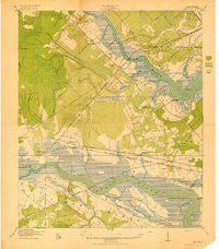
~ Johns Island SC topo map, 1:21120 scale, 7.5 X 7.5 Minute, Historical, 1919
Johns Island, South Carolina, USGS topographic map dated 1919.
Includes geographic coordinates (latitude and longitude). This topographic map is suitable for hiking, camping, and exploring, or framing it as a wall map.
Printed on-demand using high resolution imagery, on heavy weight and acid free paper, or alternatively on a variety of synthetic materials.
Topos available on paper, Waterproof, Poly, or Tyvek. Usually shipping rolled, unless combined with other folded maps in one order.
- Product Number: USGS-5686557
- Free digital map download (high-resolution, GeoPDF): Johns Island, South Carolina (file size: 18 MB)
- Map Size: please refer to the dimensions of the GeoPDF map above
- Weight (paper map): ca. 55 grams
- Map Type: POD USGS Topographic Map
- Map Series: HTMC
- Map Verison: Historical
- Cell ID: 22676
- Scan ID: 260678
- Woodland Tint: Yes
- Survey Year: 1918
- Datum: Unstated
- Map Projection: Unstated
- Map published by United States Geological Survey
- Map published by United States Army Corps of Engineers
- Map published by United States Department of War
- Map Language: English
- Scanner Resolution: 600 dpi
- Map Cell Name: Johns Island
- Grid size: 7.5 X 7.5 Minute
- Date on map: 1919
- Map Scale: 1:21120
- Geographical region: South Carolina, United States
Neighboring Maps:
All neighboring USGS topo maps are available for sale online at a variety of scales.
Spatial coverage:
Topo map Johns Island, South Carolina, covers the geographical area associated the following places:
- Sylecope - Sherwood Forest - Wappoo Shores - Essex Village - Pierpont - Marsh Cove - Wando Woods - North Pine Point - Dupont Station - Glyn Terrace - Fort Bull - Church Creek - Orleans Estates - Sylvia Lane - Bennett - Wando Gardens - Edgewater Park - Ashley Villas - Orange Grove Estates - Johns Island - Hickory Hall Plantation - Stono Station - Castlewood - Shadowmoss - Faber Place - Green Grove - Forest Lakes - Stone Park - Dogwood Gardens - Plantation Estates - Parkdale - Huntington Woods - Joshua - Cohen Hill - Heathwood - Springfield - Parsonage Point - Greenwood Park - Ponderosa - Brentwood - Saint Andrews Heights - Long Branch Estates - Evanston Estates - Oak Ridge - Oakland - Ashley Harbor - Red Top - Covington Hills - Melrose - Capri Isles - Shell Point - Murry Hill - Magnolia Ranch - Ashley Acres - Fetteressa - Ashley Hall Manor - Indigo Point - Harrison Acres - Bon Aire - Myrtle Grove - Limehouse Station - Sandy - Pinecrest - Forest Acres West - Hickory Hill - Drayton - Orleans Woods
- Map Area ID: AREA32.87532.75-80.125-80
- Northwest corner Lat/Long code: USGSNW32.875-80.125
- Northeast corner Lat/Long code: USGSNE32.875-80
- Southwest corner Lat/Long code: USGSSW32.75-80.125
- Southeast corner Lat/Long code: USGSSE32.75-80
- Northern map edge Latitude: 32.875
- Southern map edge Latitude: 32.75
- Western map edge Longitude: -80.125
- Eastern map edge Longitude: -80


