
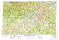
~ Greenville SC topo map, 1:250000 scale, 1 X 2 Degree, Historical, 1954, updated 1976
Greenville, South Carolina, USGS topographic map dated 1954.
Includes geographic coordinates (latitude and longitude). This topographic map is suitable for hiking, camping, and exploring, or framing it as a wall map.
Printed on-demand using high resolution imagery, on heavy weight and acid free paper, or alternatively on a variety of synthetic materials.
Topos available on paper, Waterproof, Poly, or Tyvek. Usually shipping rolled, unless combined with other folded maps in one order.
- Product Number: USGS-5389152
- Free digital map download (high-resolution, GeoPDF): Greenville, South Carolina (file size: 27 MB)
- Map Size: please refer to the dimensions of the GeoPDF map above
- Weight (paper map): ca. 55 grams
- Map Type: POD USGS Topographic Map
- Map Series: HTMC
- Map Verison: Historical
- Cell ID: 68808
- Scan ID: 262047
- Imprint Year: 1976
- Woodland Tint: Yes
- Edit Year: 1964
- Datum: Unstated
- Map Projection: Transverse Mercator
- Map published by United States Geological Survey
- Map published by United States Army Corps of Engineers
- Map Language: English
- Scanner Resolution: 600 dpi
- Map Cell Name: Greenville
- Grid size: 1 X 2 Degree
- Date on map: 1954
- Map Scale: 1:250000
- Geographical region: South Carolina, United States
Neighboring Maps:
All neighboring USGS topo maps are available for sale online at a variety of scales.
Spatial coverage:
Topo map Greenville, South Carolina, covers the geographical area associated the following places:
- Edens (historical) - Quebec (historical) - Whitmire - Osborn - Easley - Holly Springs - Rock Creek - Frazier - Dellwood - Spilo (historical) - Ware Place - Whispering Pines - Bailey - Loran Point - Lake Ridge - Dillard - La France - Anderson Village - Clemson Forest - Squirrel Creek - Fains Store - Bryson (historical) - Flat Rock - Ellenwood Acres - Fox Hollow - Magnolia Place - Cedar Lane Gardens - Cold Spring - Hill and Dale - Calhoun Falls - Seneca - Lakeshore Estates - Holly Springs - Red Hill - Trudy - Danielsville - Harbor Heights - Simpson (historical) - Gary Creek - Victorian Hills - Pine Grove Hills - Fain - Tanner Mill - Sagamore - Lake Barcroft Acres - Latimer - Jamestown Estates - Campbell - The Highlands - Fairview - Mansfield Park - Snug Harbor - Cherokee Farms - Tokeena Point - Alto - Gumlog - Ethridge - Chesterfield Estates - Scoutland - Cherokee Gardens - Brookside Village - Constantine - Jones (historical) - Hampton Heights - Presley - Rockvale - Salem - Mountain Estates - Cunningham - Lakeland Heights - East Gate Village - Bradley Corner - Batesville - Bolman Estates - Moody Cove - Traber - Indian Oaks - Maplewood - Clarksboro - Shiloh - Pebble Brook - The Circles - Collins Creek - Lawson Highlands - Tapawingo - The Bluffs - Cherokee Forest - Indian Trail - Iris - Stay (historical) - Sherwood Forest - Supreme Forest - Drake - Goochville - Smithville (historical) - Nine Times - Cold Point - Parker - Huntington Hills - Deans
- Map Area ID: AREA3534-84-82
- Northwest corner Lat/Long code: USGSNW35-84
- Northeast corner Lat/Long code: USGSNE35-82
- Southwest corner Lat/Long code: USGSSW34-84
- Southeast corner Lat/Long code: USGSSE34-82
- Northern map edge Latitude: 35
- Southern map edge Latitude: 34
- Western map edge Longitude: -84
- Eastern map edge Longitude: -82


