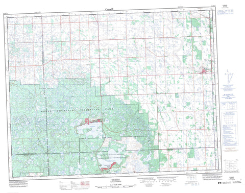
062E16 Dumas Canada topo map, 1:50,000 scale
062E16 Dumas NRCAN topographic map.
Includes UTM and GPS geographic coordinates (latitude and longitude). This 50k scale map is suitable for hiking, camping, and exploring, or you could frame it as a wall map.
Printed on-demand using high resolution, on heavy weight and acid free paper, or as an upgrade on a variety of synthetic materials.
Topos available on paper, Waterproof, Poly, or Tyvek. Usually shipping rolled, unless combined with other folded maps in one order.
- Product Number: NRCAN-062E16
- Parent Topo: TOPO-062E
- Map ID also known as: 062E16, 62E16
- Unfolded Size: Approximately 26" high by 36" wide
- Weight (paper map): ca. 55 grams
- Map Type: POD NRCAN Topographic Map
- Map Scale: 1:50,000
- Geographical region: Saskatchewan, Canada
Neighboring Maps:
All neighboring Canadian topo maps are available for sale online at 1:50,000 scale.
Purchase the smaller scale map covering this area: Topo-062E
Spatial coverage:
Topo map sheet 062E16 Dumas covers the following places:
- Christopher Bay - Pickerel Point - Cannington Lake - Pheasant Rump Nakota - White Bear 70 - Hog Island - Alkali Lake - Ashley Lake - Beaver Lake - Beaverdam Lake - Bennett Lake - Big Chain Lake - Big Marsh Lake - Birch Lake - Brownlee Lake - Cann Lake - Cannington Lake - Charles Lake - Clearwater Lake - Code Lake - Cope Lake - Corner Lake - Corral Lake - Crane Lake - Crescent Lake - Deadmans Lake - Deep Water Lake - Dermody Lake - East Two Island Lake - Gillis Lake - Goose Lake - Hawk Lake - Hewitt Lake - Hoppertown Lake - Horse Lake - Horseshoe Lake - Jabe Lake - Kenosee Lake - Kerr Lake - Lake Twelve - Little Chain Lake - Little Fish Lake - Little Kenosee Lake - Little White Bear Lake - Loon Lake - McFarlane Lake - McGurk Lake - McLellan Lake - McMillan Lake - Moose Lake - Morrison Lake - Mud Lake - Muskrat Lake - Nixon Lake - Pocket Lake - Rock Island Lake - Rock Lake - Sandy Lake - Scott and Ray Lake - Skeleton Lake - South Gate Lake - Spring Lake - Stevenson Lake - Stirrup Lake - Stony Lake - Tepee Lake - Thompson Lake - Twin Lakes - Wampos Lake - Weatherald Lake - Weatherall Lake - White Bear (Carlyle) Lake - Whitetail Lake - Youell Lake - Heart Hill - Moose Mountain - Brock No. 64 - Hazelwood No. 94 - Moose Mountain No. 63 - Walpole No. 92 - Wawken No. 93 - Moose Mountain Provincial Forest - Moose Mountain Provincial Park - Antler River - Auburnton Creek - Lightning Creek - Little Pipestone Creek - Montgomery Creek - Weatherald Creek - Wawota - Arcola Bay Resort - Carlyle Lake Resort - Crystal Hill - Dumas - Fletwode - Glen Adelaide - Highview - Kenosee Park - Sunnybank Resort - Kenosee Lake - We-Non-Cha