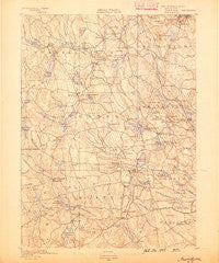
~ Burrillville RI topo map, 1:62500 scale, 15 X 15 Minute, Historical, 1889
Burrillville, Rhode Island, USGS topographic map dated 1889.
Includes geographic coordinates (latitude and longitude). This topographic map is suitable for hiking, camping, and exploring, or framing it as a wall map.
Printed on-demand using high resolution imagery, on heavy weight and acid free paper, or alternatively on a variety of synthetic materials.
Topos available on paper, Waterproof, Poly, or Tyvek. Usually shipping rolled, unless combined with other folded maps in one order.
- Product Number: USGS-5604496
- Free digital map download (high-resolution, GeoPDF): Burrillville, Rhode Island (file size: 8 MB)
- Map Size: please refer to the dimensions of the GeoPDF map above
- Weight (paper map): ca. 55 grams
- Map Type: POD USGS Topographic Map
- Map Series: HTMC
- Map Verison: Historical
- Cell ID: 51954
- Scan ID: 353474
- Survey Year: 1888
- Datum: Unstated
- Map Projection: Unstated
- Map published by United States Geological Survey
- Map Language: English
- Scanner Resolution: 600 dpi
- Map Cell Name: Burriville
- Grid size: 15 X 15 Minute
- Date on map: 1889
- Map Scale: 1:62500
- Geographical region: Rhode Island, United States
Neighboring Maps:
All neighboring USGS topo maps are available for sale online at a variety of scales.
Spatial coverage:
Topo map Burrillville, Rhode Island, covers the geographical area associated the following places:
- Simmonsville - Stillwater - Simmons Corner - Spring Grove - Kent (historical) - South Foster - Richmond (historical) - Round Top - Chopmist - Rockland (historical) - Oakland - Union Village - Harrisville - Mapleville - Spragueville - Graniteville - Glendale - Primrose - Chepachet - Gazzaville - Laurel Hill - Waldron Corners - Globe - North Smithfield - Branch Village - Tarkiln - Huntsville - Fountain Spring - Ponaganset (historical) - Field Station (historical) - Clayville - Foster Center - Smithfield - West Greenville - Harmony - Saundersville - Elmdale (historical) - Oak Valley - Harrisdale - Pascoag - Bishop Heights - Nasonville - Whipple - Forestdale - Bridgeton - Comstock Gardens - Hopkins Mills - South Scituate (historical) - North Scituate - Cherry Valley - Mohegan - Wescott Beach - Greenville - Ashland (historical) - Georgiaville
- Map Area ID: AREA4241.75-71.75-71.5
- Northwest corner Lat/Long code: USGSNW42-71.75
- Northeast corner Lat/Long code: USGSNE42-71.5
- Southwest corner Lat/Long code: USGSSW41.75-71.75
- Southeast corner Lat/Long code: USGSSE41.75-71.5
- Northern map edge Latitude: 42
- Southern map edge Latitude: 41.75
- Western map edge Longitude: -71.75
- Eastern map edge Longitude: -71.5