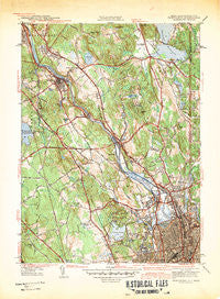
~ Pawtucket RI topo map, 1:31680 scale, 7.5 X 7.5 Minute, Historical, 1942
Pawtucket, Rhode Island, USGS topographic map dated 1942.
Includes geographic coordinates (latitude and longitude). This topographic map is suitable for hiking, camping, and exploring, or framing it as a wall map.
Printed on-demand using high resolution imagery, on heavy weight and acid free paper, or alternatively on a variety of synthetic materials.
Topos available on paper, Waterproof, Poly, or Tyvek. Usually shipping rolled, unless combined with other folded maps in one order.
- Product Number: USGS-5604426
- Free digital map download (high-resolution, GeoPDF): Pawtucket, Rhode Island (file size: 10 MB)
- Map Size: please refer to the dimensions of the GeoPDF map above
- Weight (paper map): ca. 55 grams
- Map Type: POD USGS Topographic Map
- Map Series: HTMC
- Map Verison: Historical
- Cell ID: 34471
- Scan ID: 353438
- Woodland Tint: Yes
- Survey Year: 1938
- Datum: NAD27
- Map Projection: Polyconic
- Map published by United States Army
- Map Language: English
- Scanner Resolution: 600 dpi
- Map Cell Name: Pawtucket
- Grid size: 7.5 X 7.5 Minute
- Date on map: 1942
- Map Scale: 1:31680
- Geographical region: Rhode Island, United States
Neighboring Maps:
All neighboring USGS topo maps are available for sale online at a variety of scales.
Spatial coverage:
Topo map Pawtucket, Rhode Island, covers the geographical area associated the following places:
- Quinnville - Cumberland Hill - Lonsdale - Abbott Run - Manville - Fairlawn - Lime Rock - Ashton - Berkeley - Central Falls - Saylesville Highlands - Pleasant View - Cumberland Mills - Arnold Mills - Cumberland - Lippitt Estate - Sayles Bleachery - Monastery Heights - Happy Hollow - Albion - Valley Falls - Saylesville - Pawtucket - Diamond Hill
- Map Area ID: AREA4241.875-71.5-71.375
- Northwest corner Lat/Long code: USGSNW42-71.5
- Northeast corner Lat/Long code: USGSNE42-71.375
- Southwest corner Lat/Long code: USGSSW41.875-71.5
- Southeast corner Lat/Long code: USGSSE41.875-71.375
- Northern map edge Latitude: 42
- Southern map edge Latitude: 41.875
- Western map edge Longitude: -71.5
- Eastern map edge Longitude: -71.375