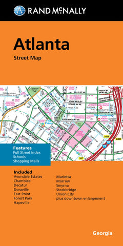
Atlanta : street map
Rand McNallys folded map for Atlanta is a must-have for anyone traveling in and around this part of Georgia, offering unbeatable accuracy and reliability at a great price. Our trusted cartography shows all Interstate, U.S., state, and county highways, along with clearly indicated parks, points of interest, airports, county boundaries, and streets. The easy-to-use legend and detailed index make for quick and easy location of destinations. Youll see why Rand McNally folded maps have been the trusted standard for years. Regularly updated full-color maps. Clearly labeled Interstate, U.S., state, and county highways. Indications of parks, points of interest, airports, county boundaries, schools, shopping malls, downtown & vicinity maps. Easy-to-use legend. Detailed index & full street index. Convenient folded size. Communities Included: Avondale Estates, Chamblee, Decatur, Doraville, East Point, Forest Park, Hapeville, Marietta, Morrow, Smyrna, Stockbridge, Union City plus downtown enlarg
- Product Number: RM_ATL_22
- Reference Product Number: - None -
- ISBN: 9780528024450
- Date of Publication: 6/1/2022
- Folded Size: 9.06 inches high by 4.72 inches wide
- Unfolded (flat) Size: 36.02 inches high by 44.88 inches wide
- Map format: Folded
- Map type: Trade Maps - City Maps
- Geographical region: United States
- Geographical subregion: Georgia