
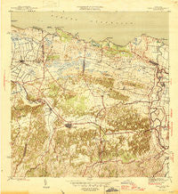
~ Vega Alta PR topo map, 1:30000 scale, 7.5 X 7.5 Minute, Historical, 1946
Vega Alta, Puerto Rico, USGS topographic map dated 1946.
Includes geographic coordinates (latitude and longitude). This topographic map is suitable for hiking, camping, and exploring, or framing it as a wall map.
Printed on-demand using high resolution imagery, on heavy weight and acid free paper, or alternatively on a variety of synthetic materials.
Topos available on paper, Waterproof, Poly, or Tyvek. Usually shipping rolled, unless combined with other folded maps in one order.
- Product Number: USGS-5655590
- Free digital map download (high-resolution, GeoPDF): Vega Alta, Puerto Rico (file size: 10 MB)
- Map Size: please refer to the dimensions of the GeoPDF map above
- Weight (paper map): ca. 55 grams
- Map Type: POD USGS Topographic Map
- Map Series: HTMC
- Map Verison: Historical
- Cell ID: 46712
- Scan ID: 362600
- Woodland Tint: Yes
- Datum: Puerto Rico
- Map Projection: Polyconic
- Map published by United States Geological Survey
- Map Language: English
- Scanner Resolution: 600 dpi
- Map Cell Name: Vega Alta
- Grid size: 7.5 X 7.5 Minute
- Date on map: 1946
- Map Scale: 1:30000
- Geographical region: Puerto Rico, United States
Neighboring Maps:
All neighboring USGS topo maps are available for sale online at a variety of scales.
Spatial coverage:
Topo map Vega Alta, Puerto Rico, covers the geographical area associated the following places:
- Costa de Oro - Central Carmen (historical) - Casa del Rey - Boulevarda Vientan - Jardines de Dorado - Villa Linares - Villa Santa - Boulevarda Korea - Sector Vista Alegre - Brisa del Plata - Sabana - Ceiba Comunidad - Dorado Zona Urbana - La Aldea - Villa Matilde - Reparto Diaz - Mameyal - Regadera - Villas de Playa II - Quintas de Dorado - Dorado - Residencial Francisco Vega Sanchez - Espinosa - El Coto - Extension Higuillar - Vega Alta - Brenas - Cerro Gordo - Minima San Antonio - Paseo de Dorado - Mi Querido Viejo - Punto Cubano - Villa Amparo - Comunidad La Ponderosa - Monserrate - Doraville - Ceiba - La Inmaculada II - Higuillar - Sabana Comunidad - Monte Lindo - Jardines de Toa Alta - Martonnel - Los Puertos - Monterrey - San Fernando - Toa Baja - Santa Rita - El Polvorín - Dorado del Mar - Monserrate Comunidad - San Antonio Comunidad - Residencial Las Videtas - Villa Palma - San Carlos - Los Colinas - Vega Alta Zona Urbana - Santa Rosa - San José - Comunidad Carmen - San Antonio - Breñas Comunidad - Río Lajas Comunidad - La Inmaculada - Costa Dorado - Toa Baja Zona Urbana - Río Lajas - Town Hills - Toa Alta Zona Urbana
- Map Area ID: AREA18.518.375-66.375-66.25
- Northwest corner Lat/Long code: USGSNW18.5-66.375
- Northeast corner Lat/Long code: USGSNE18.5-66.25
- Southwest corner Lat/Long code: USGSSW18.375-66.375
- Southeast corner Lat/Long code: USGSSE18.375-66.25
- Northern map edge Latitude: 18.5
- Southern map edge Latitude: 18.375
- Western map edge Longitude: -66.375
- Eastern map edge Longitude: -66.25


