
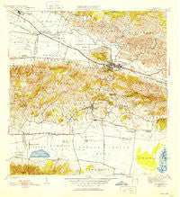
~ San German PR topo map, 1:30000 scale, 7.5 X 7.5 Minute, Historical, 1941, updated 1952
San German, Puerto Rico, USGS topographic map dated 1941.
Includes geographic coordinates (latitude and longitude). This topographic map is suitable for hiking, camping, and exploring, or framing it as a wall map.
Printed on-demand using high resolution imagery, on heavy weight and acid free paper, or alternatively on a variety of synthetic materials.
Topos available on paper, Waterproof, Poly, or Tyvek. Usually shipping rolled, unless combined with other folded maps in one order.
- Product Number: USGS-5655554
- Free digital map download (high-resolution, GeoPDF): San German, Puerto Rico (file size: 10 MB)
- Map Size: please refer to the dimensions of the GeoPDF map above
- Weight (paper map): ca. 55 grams
- Map Type: POD USGS Topographic Map
- Map Series: HTMC
- Map Verison: Historical
- Cell ID: 39622
- Scan ID: 362580
- Imprint Year: 1952
- Edit Year: 1949
- Survey Year: 1937
- Datum: Puerto Rico
- Map Projection: Polyconic
- Map published by United States Geological Survey
- Map Language: English
- Scanner Resolution: 600 dpi
- Map Cell Name: San German
- Grid size: 7.5 X 7.5 Minute
- Date on map: 1941
- Map Scale: 1:30000
- Geographical region: Puerto Rico, United States
Neighboring Maps:
All neighboring USGS topo maps are available for sale online at a variety of scales.
Spatial coverage:
Topo map San German, Puerto Rico, covers the geographical area associated the following places:
- Margarita - Santa Marta - Lajas Arriba - San Germán Zona Urbana - Alturas de Lajas Number 1 - El Recreo - Guanábana - Hacienda Beatriz Soledad - Palmarejo - El Valle - Lajas Zona Urbana - Parada de Señal Fulminante - Extension El Valle - Jardines de Lajas - Hacienda Resolución - Hacienda Coto - Maguayo - Hacienda Julia - Vivoni - San Germán - Hacienda Desengaño - El Retiro - Finca Juanita - Alturas de Lajas Number 2 - Sabana Eneas Comunidad - Hospital Concepcion - Barriada Tomei - Sabana Eneas - Lajas - Palmarejo Comunidad - San Ramón - Reparto El Valle - Hacienda Luisa - Sector Piedras Blancas - Llanos - El Brujo - Riverside - Monte Grande - Maguayo Comunidad - Monte Grande Comunidad - Parada de Señal Irizarry - Olivares - Coto - Filial Amor (historical) - Porta Coeli
- Map Area ID: AREA18.12518-67.125-67
- Northwest corner Lat/Long code: USGSNW18.125-67.125
- Northeast corner Lat/Long code: USGSNE18.125-67
- Southwest corner Lat/Long code: USGSSW18-67.125
- Southeast corner Lat/Long code: USGSSE18-67
- Northern map edge Latitude: 18.125
- Southern map edge Latitude: 18
- Western map edge Longitude: -67.125
- Eastern map edge Longitude: -67


