
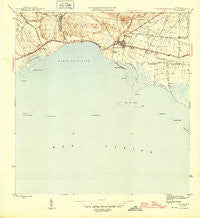
~ Salinas PR topo map, 1:30000 scale, 7.5 X 7.5 Minute, Historical, 1945
Salinas, Puerto Rico, USGS topographic map dated 1945.
Includes geographic coordinates (latitude and longitude). This topographic map is suitable for hiking, camping, and exploring, or framing it as a wall map.
Printed on-demand using high resolution imagery, on heavy weight and acid free paper, or alternatively on a variety of synthetic materials.
Topos available on paper, Waterproof, Poly, or Tyvek. Usually shipping rolled, unless combined with other folded maps in one order.
- Product Number: USGS-5655542
- Free digital map download (high-resolution, GeoPDF): Salinas, Puerto Rico (file size: 7 MB)
- Map Size: please refer to the dimensions of the GeoPDF map above
- Weight (paper map): ca. 55 grams
- Map Type: POD USGS Topographic Map
- Map Series: HTMC
- Map Verison: Historical
- Cell ID: 39455
- Scan ID: 362573
- Datum: Puerto Rico
- Map Projection: Polyconic
- Map published by United States Geological Survey
- Map Language: English
- Scanner Resolution: 600 dpi
- Map Cell Name: Salinas
- Grid size: 7.5 X 7.5 Minute
- Date on map: 1945
- Map Scale: 1:30000
- Geographical region: Puerto Rico, United States
Neighboring Maps:
All neighboring USGS topo maps are available for sale online at a variety of scales.
Spatial coverage:
Topo map Salinas, Puerto Rico, covers the geographical area associated the following places:
- Fortuna - Hacienda Teresa - Las Marías - Salimar - Jauca - Residencial Modesto Cintron - Jaguas - Playa de Salinas - Santiago - Residencial Bella Vista - Playita Comunidad - Salinas - Las Mercedes - Arenal - Las Ochenta - Hacienda Palés - Parcelas Peñuelas - Magdalena - Playita - Hacienda Margarita - Esperanza - La Arboleda - Jauca Comunidad - La Carmen - Las Antillas - Extension La Carmen - Hacienda Carmen - Monserrate - Colonia Bomba (historical) - Las Ochenta Comunidad - Las Mareas - Salinas Zona Urbana
- Map Area ID: AREA1817.875-66.375-66.25
- Northwest corner Lat/Long code: USGSNW18-66.375
- Northeast corner Lat/Long code: USGSNE18-66.25
- Southwest corner Lat/Long code: USGSSW17.875-66.375
- Southeast corner Lat/Long code: USGSSE17.875-66.25
- Northern map edge Latitude: 18
- Southern map edge Latitude: 17.875
- Western map edge Longitude: -66.375
- Eastern map edge Longitude: -66.25


