
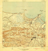
~ Bayamon PR topo map, 1:30000 scale, 7.5 X 7.5 Minute, Historical, 1941
Bayamon, Puerto Rico, USGS topographic map dated 1941.
Includes geographic coordinates (latitude and longitude). This topographic map is suitable for hiking, camping, and exploring, or framing it as a wall map.
Printed on-demand using high resolution imagery, on heavy weight and acid free paper, or alternatively on a variety of synthetic materials.
Topos available on paper, Waterproof, Poly, or Tyvek. Usually shipping rolled, unless combined with other folded maps in one order.
- Product Number: USGS-5655144
- Free digital map download (high-resolution, GeoPDF): Bayamon, Puerto Rico (file size: 8 MB)
- Map Size: please refer to the dimensions of the GeoPDF map above
- Weight (paper map): ca. 55 grams
- Map Type: POD USGS Topographic Map
- Map Series: HTMC
- Map Verison: Historical
- Cell ID: 2723
- Scan ID: 362336
- Datum: Puerto Rico
- Map Projection: Polyconic
- Map published by United States Geological Survey
- Map Language: English
- Scanner Resolution: 600 dpi
- Map Cell Name: Bayamon
- Grid size: 7.5 X 7.5 Minute
- Date on map: 1941
- Map Scale: 1:30000
- Geographical region: Puerto Rico, United States
Neighboring Maps:
All neighboring USGS topo maps are available for sale online at a variety of scales.
Spatial coverage:
Topo map Bayamon, Puerto Rico, covers the geographical area associated the following places:
- Ingenio Comunidad - Puente Blanco - Teresita - La Arena - Bayamón Zona Urbana - Mansion del Rio - Punta Brava - Bucarabones - Sabana Seca - Magnolia Gardens - La Monserrate - Flamingo Hills - Quintas de Flamingo - Camino Delmar - Villa Kenny - Las Vegas - Volcan - Campanilla - Forest Hills - Las Palmas - Campanilla Comunidad - Residencial El Coqui - Levittown - Tintillo - Palo Seco - El Plantino - Pradera - Royal Gardens - Valle Verde - Las Arenas - Riverview - Riverview - Pájaros - Bayamón - Victoria Heights - Candelaria Arenas - Plantaje - San José Comunidad - Extension Sierra Bayamon - Quintas del Rio - Macún - Bay View - Alturas de Flamboyan - Bayamón Gardens - Parker - Flamboyant Gardens - La Cambija - Sierra Bayamon - Sierra Bayamón - La Miligrosa - Rio Hondo IV - Dos Rios - Santa Mónica - Centro de Detencion Regional - Cataño Zona Urbana - Monte Claro - Sierra Linda - El Naranjal - Mansion del Norte - Mucarabones - Valencia - Juana Matos - Marina Bahia - Fronteras de Bayamon - Lagos de Norte - Santa Rosa - Oliver - Sabana Seca Comunidad - Residencial Juana Matos - Almira - Comunidad Rio Plantation - Los Magos - Campo Verde - Villas de Levittown - Toa Alta - Cucharillas - Vista del Morro - Hato Tejas - Volcán - Candelaria - Chalets de Bayamon - Villa Contessa - Villas de Sabana - Santa Cruz - San Rafael State - La Aldea - Enramada - Villa Rica - Mansion del Sur - Vista Alegre - El Frutal - Ingenio - Villa Marasol - Olazabal - Candelaria Comunidad - Residencial Brisas de Bayamon - Valparaiso - Los Grillos - Davila - Mucarabones Comunidad
- Map Area ID: AREA18.518.375-66.25-66.125
- Northwest corner Lat/Long code: USGSNW18.5-66.25
- Northeast corner Lat/Long code: USGSNE18.5-66.125
- Southwest corner Lat/Long code: USGSSW18.375-66.25
- Southeast corner Lat/Long code: USGSSE18.375-66.125
- Northern map edge Latitude: 18.5
- Southern map edge Latitude: 18.375
- Western map edge Longitude: -66.25
- Eastern map edge Longitude: -66.125


