
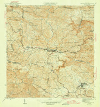
~ Barranquitas PR topo map, 1:30000 scale, 7.5 X 7.5 Minute, Historical, 1946
Barranquitas, Puerto Rico, USGS topographic map dated 1946.
Includes geographic coordinates (latitude and longitude). This topographic map is suitable for hiking, camping, and exploring, or framing it as a wall map.
Printed on-demand using high resolution imagery, on heavy weight and acid free paper, or alternatively on a variety of synthetic materials.
Topos available on paper, Waterproof, Poly, or Tyvek. Usually shipping rolled, unless combined with other folded maps in one order.
- Product Number: USGS-5655138
- Free digital map download (high-resolution, GeoPDF): Barranquitas, Puerto Rico (file size: 12 MB)
- Map Size: please refer to the dimensions of the GeoPDF map above
- Weight (paper map): ca. 55 grams
- Map Type: POD USGS Topographic Map
- Map Series: HTMC
- Map Verison: Historical
- Cell ID: 69265
- Scan ID: 362333
- Visual Version Number: 1
- Datum: Puerto Rico
- Map Projection: Polyconic
- Map published by United States Geological Survey
- Map Language: English
- Scanner Resolution: 600 dpi
- Map Cell Name: Barranquitas
- Grid size: 7.5 X 7.5 Minute
- Date on map: 1946
- Map Scale: 1:30000
- Geographical region: Puerto Rico, United States
Neighboring Maps:
All neighboring USGS topo maps are available for sale online at a variety of scales.
Spatial coverage:
Topo map Barranquitas, Puerto Rico, covers the geographical area associated the following places:
- Caonillas - Barranquitas Zona Urbana - Reparto Bella Vista - Villa Ronga - La Guitarra - Villa Rosales - Quebrada Grande - Helechal - Palomas - San Jose - Palomas Comunidad - Torres - Sector Villa Casino - Carro - La Vega - Estancias Del Llano - Villa Verde - Aibonito - Barrancas - Las Flores - Asomante - Hacienda Córcega - El Cartijo - Paseo Monte Carlos - Residencial Villa Universidad - Campo Rey - Las Quintas - Aibonito Zona Urbana - Reparto Colinas de Monte Verde - Santa Ana - Barranquitas - Jardines de Aibonito - Botijas - Brisas de Aibonito - Comunidad San Luis
- Map Area ID: AREA18.2518.125-66.375-66.25
- Northwest corner Lat/Long code: USGSNW18.25-66.375
- Northeast corner Lat/Long code: USGSNE18.25-66.25
- Southwest corner Lat/Long code: USGSSW18.125-66.375
- Southeast corner Lat/Long code: USGSSE18.125-66.25
- Northern map edge Latitude: 18.25
- Southern map edge Latitude: 18.125
- Western map edge Longitude: -66.375
- Eastern map edge Longitude: -66.25


